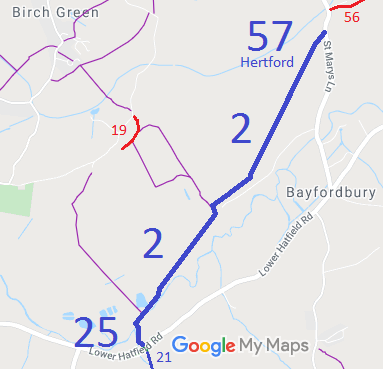
Annotated map reproduced courtesy of Googlemaps.
| Paths Greenways Bridleways Tracks | ||
| PG: OBJECTS: PROMOTION: Hertingfordbury 2 BW, Hertford 57 BW and Little Berkhamsted 25 BW | ||
Annotated map reproduced courtesy of Googlemaps. |
This route runs from Lower Hatfield Road (public road) to St Mary's Lane (public road). |
| Legal History 2 Feb 1953: Little Berkhamsted 25, Hertingforbury 2 and Hertford 58 were recorded as bridleways on the original definitive map and statement. DM sheets DM2-22 and DM2-29. 2 Feb 1953: Hertford 57 was recorded as a C.R.F. (Carriage Road used as a Footpath) on the original definitive statement. DM sheet DM2-29. Hertingforbury 2 appears to have been subject to a diversion near Roxford Farm. 31 Dec 1977: Little Berkhamsted 25, Hertingfordbury 2 and Hertford 57 and 58 were shown as bridleways on the special review draft map and statement. DM sheet SR-70, SR-58 and SR-59. Hertford 57 and 58 were subsequently combined and the resulting path shown as Hertford 57 bridleway. |
Definitive Statement (4 Dec 2015)
Path: [Hertingfordbury] 2. Status: Bridleway. Definitive Map sheets: 58, 59, 70 Commences from parish boundary E of Water Hall Farm thence NE past Water House to Roxford thence runs generally NW of Roxford Barn to TL 3026 1047 thence generally NE past Chalk Dell and Leaside Cottage through Southfield Wood to parish boundary. Width: 4m between TL 3020 1031 and TL 3048 1067 Limitations: None Path: [Little Berkhamsted] 25. Status: Bridleway.
Definitive Map sheet: 70 Path: [Hertford] 57. Status: Bridleway.
Definitive Map sheet: 59 |
© 2021 Patchetts Green Bridleways Trust.