| Paths Greenways Bridleways Tracks | ||
| PG: OBJECTS: PROMOTION: Kings Walden Roadway to FP 27 | ||
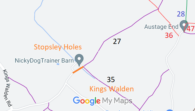
![]() Annotated map reproduced courtesy of Googlemaps. |
This route starts form the public road leading to Stopsley Holes Farm, and continues generally northeastwards to end at the juntcion of Kings Walden 27 and 35 footpaths.
We need a volunteer to photograph this route for the Access and Riding Rights of Way Survey. It's easy - just take photographs (safely) when you walk the path. Find out more! |
|||
As part of the Ramblers' Don't Lose Your Way (DLYW) project to record paths before
Path Extinguishment Day,
it was spotted that the County Council's gazetteer showed a gap between the recorded public road at the start of Kings Walden 27 footpath. previously this gap had been considered to be a part of the public road and so hadn't been recorded on the definitive map. As the historical evidence showed a continuous route and to ensure connectivity, an application was made in 2023 to record the gap.
| ||||
| Legal History 1938: The route is shown as an unclassified road on the Hertfordshire County Council ROW survey. Map Hitchin Rural West 11. 1 Nov 1953: The route was not recorded on the original definitive map and statement. DM sheet DM4-30 (Herts 11 SE). 31 Dec 1977: The route was not shown on the special review draft map and statement. DM sheet SR-28 (TL12SE). 23 Aug 2023: Application to record gap as byway. HCC reference NH/350. |
Definitive Statement (4 Dec 2015)
Adjoining Path: [Kings Walden] 27. Recorded Status: Footpath. Definitive Map sheet: 20 Commences from end of county road at Stopsley - Holes thence NE across Restricted Byway 36 to parish boundary at SE corner of West Wood to join FP7 and BR11 (Preston). Adjoining Path: [Kings Walden] 35. Recorded Status: Footpath.
Definitive Map sheet: 28 |
© 2024 Patchetts Green Bridleways Trust. File reference: EC704. DLYW reference: 206116. HCC reference: NH/350