Legal History
1938: The route is not shown on the Hertfordshire County Council ROW survey. Map Hitchin West 15 and 16.
1 Nov 1953: Parts of the route were recorded as footpaths Knebworth 28 and Knebworth 40 on the original definitive map and statement. DM sheets DM4-40 and DM4-41.
31 Dec 1977: Parts of the route were shown as bridleways on the special review draft map and statement. DM sheet SR-29.
16 May 1994: EHFS application to add route as a byway. HCC reference NH/76.
23 Jul 2004: The Hertfordshire County Council (Dyes Lane, Langley
21/Knebworth 43) Modification Order 2004 (confirmed 31 Oct 2007) added this route to the definitive map and statement.
|
Definitive Statement (4 Dec 2015)
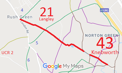
Path: [Langley] 21. Status: BOAT
Definitive Map sheet: 29
Dyes Lane commences at junction with B656 London Road and Langley Bridleway 004 at
TL2098 2364, thence SE for approximately 860m to a culvert at Dyes Farm (TL2174 2326).
Then continuing SE for a further 250m to a right-angled bend around the north side of the pond and continuing SE to the parish boundary to join Knebworth BOAT 28a at TL2221 2306.
Width: Varies between 4.7m and 27m
Path: [Knebworth] 43. Status: Byway Open to All Traffic.
Definitive Map sheet: 29
Dyes Lane commences from Knebworth BOAT 28a at NE corner of Oak Grove (TL2237
2297) thence SE for approximately 180m to crossing with Knebworth FP 42 (TL2254 2290),
then continues SE for a further 210m to join Knebworth BOAT 40 at TL2272 2279.
Width: Varies between 6m and 14m
|
 Mark Westley of the East Herts Footpaths Society applied for this route to be recorded.
The County Council agreed with the application and an order was made in 2004. It attracted four objections and so a public inquiry was held. The Inspector confirmed the order with minor modifications.
