Paths Greenways Bridleways Tracks
 PG: OBJECTS: PROMOTION: Lilley 20x UNRECORDED ROUTE
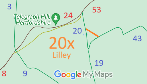
Map showing recorded Lilley paths
Annotated map reproduced courtesy of Googlemaps.
This route runs from Lilley 19 bridleway at the parish boundary, generally northwestwards to Lilley 20 bridleway.

We need a volunteer to photograph this route for this year's Access and Riding Rights of Way Survey. It's easy - just take photographs (safely) when you walk the path. Find out more!

BHS PGBT As part of the Trust's and the British Horse Society's work to record paths before Path Extinguishment Day, it was spotted that this orute was recorded by the parish and county councils in 1938. An application is being considered.

Legal History
1938: The route was shown as bridleway 20 Lilley on the Hertfordshire County Council ROW survey. Map Hitchin Rural West 7 (IX NE).
1 Nov 1953: The route was not recorded on the original definitive map and statement (but track is shown on the base map). DM sheet DM4-28 (Herts 11 NE).
31 Dec 1977: The route was not shown on the special review draft map and statement. DM sheet SR-19 (TL12NW).
Definitive Statement (4 Dec 2015)
Path: [Lilley] 20.  Status: Bridleway.  Definitive Map sheet: 19
Commences from BR 19 W of Calverswick Spring thence N to join Icknield Way (BOAT 24 Lilley-BOAT 61 Shillington (Beds.)) at TL1206 2906 at NE corner of Parish.

© 2024 Patchetts Green Bridleways Trust.