Legal History
2 Feb 1953: Little Berkhamsted 2 was recorded as a footpath on the original definitive map and statement. DM sheet DM2-29.
31 Dec 1977: Little Berkhamsted 2 was recorded as a bridleway on the special review draft map and statement. DM sheet SR-70.
11 Dec 2010: Application for bridleway status at field edge. HCC reference EH/332.
26 Sep 2014: The Little Berkhamsted Public Bridleway Creation Agreement 2014 was executed by the County Council and two landowners.
20 Nov 2015: The Hertfordshire County Council (Little Berkhamsted 2 and 27) Legal Event Modification Order 2015 recorded the bridleway on the definitive map and statement.
|
|
Definitive Statement (20 Nov 2015)
Path: [Little Berkhamsted] 2. Status: Bridleway/Footpath.
Definitive Map sheet: 70
Commences as a FP at TL 2854 0887 at junction with BR27 opposite Ashfield
Cottages thence SW to a junction with BR27 at TL 2849 0880 continuing as a BR
generally W for approx 245m to a junction with Essendon BR25 at TL 2825 0874
Bedwell Avenue and parish boundary.
Width: 5m between TL 2849 0880 and TL 2825 0874
Limitations: None
Path: [Little Berkhamsted] 27. Status: Bridleway.
Definitive Map sheet: 70
Commencing from a junction with BR18 and FP2 opposite Ashfield Cottages at
TL 2855 0887 then generally S for approx. 45m to TL 2855 0883 then generally W for
approx. 70m to a junction with BR2 and FP2 at TL 2849 0880.
Width: 2.5m between TL 2885 0887 and TL 2855 0883;
4m between TL 2855 0883 and TL 2849 0880.
Limitations: None
|
Maintainability
Little Berkhamsted 2 is maintainable at the public expense because it was a footpath or bridleway existing before 30 Apr 1959.
Little Berkhamsted 27 is maintainable at the public expense by virtue of s.36(2)(d) Highways Act 1980 as it was created by a Public Path Creation Agreement. [Dedicated by PPCA]
|
|
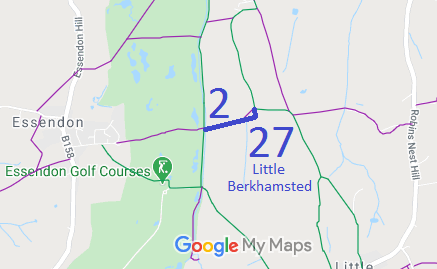
 This route had been ridden for many years, but part was recorded as part of Footpath 2 and part was unrecorded. An application was made based on user evidence but the landowner agreed to enter into a creation agreement to record the route. This saved County Council resources and meant that the route could be recorded much more quickly.
