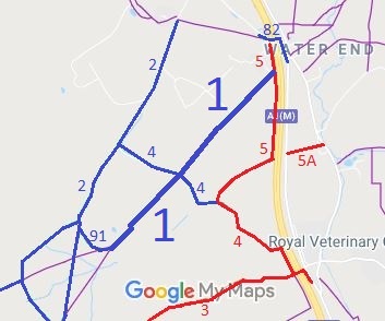
Annotated map reproduced courtesy of Googlemaps.
We need a volunteer to photograph this route for this year's Access and Riding Rights of Way Survey. It's easy - just take photographs (safely) when you use the path. Find out more!
| Patchetts Green Bridleways Trust | ||
| PG: OBJECTS: PROMOTION: North Mymms 1 | ||
Annotated map reproduced courtesy of Googlemaps. |
This route runs from byway North Mymms 5 through a junction with bridleway North Mymms 4 to end on bridleway North Mymms 91.
We need a volunteer to photograph this route for this year's Access and Riding Rights of Way Survey. It's easy - just take photographs (safely) when you use the path. Find out more! |
| Legal History Recorded as a footpath on the original (1953) definitive map. 16 Jul 1994: Application to record this route as a bridleway. 30 Jun 2017: The Hertfordshire County Council (North Mymms 90, 91 and Ridge 44) Modification Order 2017 (confirmed 1 Sep 2017) recorded North Mymms 1 as bridleway and added North Mymms 90, 91 and Ridge 44 as bridleways on the definitive map. |
Definitive Statement (13 Jun 2017)
Path: [North Mymms] 1. Status: FP/BW. Definitive Map sheet: 78 Commences as FP at junction with BR 2 at North Mymms Park Lodge on W boundary at Hawkshead Wood thence NE to a junction with North Mymms 91 at TL 2189 0320. Continuing as BR for approx 10m to a junction with FP 44 at TL 2190 0231, then NE for approx 1315m along SE edge of Cangsley Grove crossing BR 4 at TL 2225 0361 to a junction with BOAT 5 at on the W boundary of the A1(M) at TL 2276 0419. Width: 3 metres. Limitations: None. |
© 2024 Patchetts Green Bridleways Trust. File reference: EC095.