Legal History
20 Jun 1953: The route was recorded as CRF (Carriage Road used as a Footpath) on the original definitive map.
31 Dec 1977: The route was shown as a footpath on the special review draft map and statement, but objections were made to this. The Special Review was abandoned in 1984 and so this proposal did not take place. DM sheet SR-69.
1985: The Welwyn Hatfield District (Tollgate Farm, North Mymms) (Public Path Creation Diversion Extinguishment) Orders 1985 would have extinguished North Mymms 28, but following BHS objection was not confirmed.
1987: Application to Hatfield Magistrates Court to extinguish North Mymms 28. Following BHS objection, the magistrates refused the application.
4 Feb 2000: Application by landowners to downgrade to FP. HCC reference W+H/45.
2 May 2006: North Mymms 28 was not shown on the County Council's List of Streets and so this NERC exemption did not apply.
2 May 2006: Restricted Byway rights were confirmed or created on this path by virtue of ss 47 and 48 Countryside and Rights of Way Act 2000, subject to determination of earlier application.
6 Feb 2026: Hertfordshire County Council turned down the landower's application to downgrade or delete this route.
|
| Application Process |
| Path |
Application |
Certificate |
Direction |
Inv Report |
Decision |
Decision Date |
| EC226 |
4 Feb 2000 W+H45 |
unknown |
N/A |
10 Jun 2025 |
No order |
6 Feb 2026 |
|
Definitive Statement (4 Dec 2015)
Path: [North Mymms] 28. Recorded Status: Restricted Byway.
Definitive Map sheet: 69
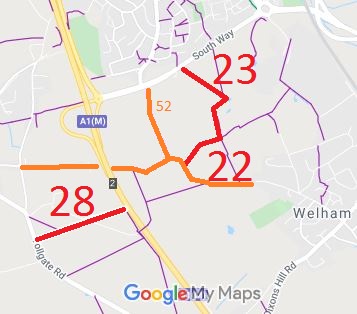
Commences from Tollgate Road S of Tollgate Farm thence NE along southern edge of
Tollgate Wood to junction with FP55 at Barnet By-pass (A1).
|
Maintainability
This route is maintainable at the public expense by virtue of s.49(1) Countryside and Rights of Way Act 2000. [RB converted from RUPP]
|
|