Legal History
20 Jun 1953: North Mymms 52 was recorded as a footpath on the original definitive map and statement.
1 Feb 2010: Application EC404 made to record part of North Mymms 52 FP as a restricted byway.
4 Feb 2019: Secretary of State directed Hertfordshire County Council to determine the application by 4 Feb 2020. (Deadline missed.)
12 Mar 2024: HCC advise investigation has started.
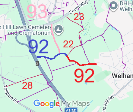
1 Oct 2026: The Hertfordshire County Council (North Mymms 92 and North Mymms 93) Modification Order 2026 (confirmed 1 Oct 2026) recorded North Mymms 93 as a restricted byway on the definitive map and statement.
|
| Application Process |
| Path |
Application |
Certificate |
Direction |
Inv Report |
Order |
Confirmed |
| EC196 |
1 Feb 2010 WH/83 |
30 Sep 2010 |
4 Feb 2019 (1yr) |
10 Jun 2025 |
21 May 2026 |
1 Oct 2026 |
EC404 |
2 Feb 2010 WH/48 |
30 Sep 2010 |
4 Feb 2019 (1yr) |
10 Jun 2025 |
21 May 2026 |
1 Oct 2026 |
|
Definitive Statement (24 Mar 2026)
Path: [North Mymms] 93. Recorded Status: BR/RB.
Definitive Map sheet: 69
Commences from a junction with North Mymms BR 92 at TL 2216 0579 then NNW for approx 440m to a
junction with South Way (A1001) at TL 2203 0621.
Width: Varies between 5m and 13m as shaded grey in the Hertfordshire County Council
(North Mymms 92 and North Mymms 93) Modification Order 2026.
Limitations: None.
|
Maintainability
This route is maintainable at the public expense because it was a highway before 1835.
|
|