Paths Greenways Bridleways Tracks
 PG: OBJECTS: PROMOTION: THREE RIVERS: Rickmansworth 71 - Shire Lane
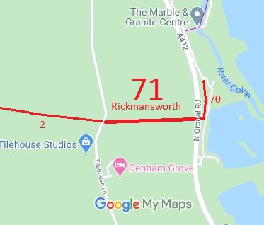
Map showing Rickmansworth 71 Shire Lane
Annotated map reproduced courtesy of Googlemaps.
This route starts from Tilehouse Lane (public road) opposite Denham 2 restricted byway, and runs eastwards to the A412 North Orbital Road (public road). It then continues for 20m on the E side of the road to reach a junction with Rickmansworth 70 Byway.

This route may be temporarily closed while HS2 works happen. Please check before use.

If it is open, we need a volunteer to photograph this route for this year's Access and Riding Rights of Way Survey. It's easy - just take photographs (safely) when you use the path. Find out more!

BHS As part of the British Horse Society's work to record paths before Path Extinguishment Day, it was identified that this route appeared to be an old road, and so an application was made to record it as a restricted byway. An application was also made to Buckinghamshire County Council, as the route was also recorded as Denham 3 bridleway on their definitive map. However, Buckinghamshire's investigation showed that the route fell entirely in Hertfordshire so it will be removed from the Buckinghamshire map in due course.
The Hertfordshire County Council agreed with the application and an order was made in 2016 and confirmed unopposed. This is a good example of 'perfectly obvious paths' that would have been extinguished by the Countryside and Rights of Way Act 2000 if an application had not been made in time.

Legal History
20 Jun 1953: Rickmansworth 2 was recorded as a bridleway on the original (1953) definitive map and statement for Hertfordshire. DM sheets DM3-35 and DM3-41.
The route was also recorded as a bridleway (Denham 3) in Buckinghamshire.
31 Dec 1977: Rickmansworth 2 was shown as a bridleway on the special review draft map and statement. DM sheet SR-88 (TQ09SW).
16 Mar 2015: Application made for restricted byway status. HCC reference 3R/86.
14 Mar 2016: Application made for restricted byway status. BCC reference 16855 BAR. This was turned down on the grounds that the route is actually outside Buckinghamshire!
4 Jul 2016: The Hertfordshire County Council (Rickmansworth 2, 70 and 71) Modification Order 2016 (confirmed 21 Oct 2016) split the original Rickmansworth 2 BW into sections, removed those that had been found to be in Buckinghamshire, and renumbered and upgraded the remaining section as Rickmansworth 71 RB. 14 Aug 2018: The Buckinghamshire County Council (Restricted Byway No.44 (Part) Chalfont St Peter and Restricted Byway No.2 Denham) Definitive Map Modification Order 2018 (confirmed 20 Jan 2020) upgraded the Buckinghamshire part of the route to restricted byway.
Definitive Statement (4 Dec 2015)
Path: [Rickmansworth] 71.  Status: Restricted Byway.  Definitive Map sheets: 82, 88
Commences from a junction with Rickmansworth BOAT 70 at TQ 0361 9005 W along Shire Lane for approx 20. to join A412 (public road) at TQ 0359 9005. Then continuing W side of A412 at TQ 0358 9005, W direction along Shire Lane for approx 390m to a junction with Tilehouse Lane (public road) and the Bucks County boundary at TQ 0319 9003.
Width: Varies between 4m to 5m between TQ 0361 9005 and TQ 0319 9003 as shown in the Hertfordshire County Council (Rickmansworth 2, 70 and 71) Modification Order 2016.
Limitations: None.
Maintainability
This route is maintainable at the public expense because it was a highway before 1835.

© 2024 Patchetts Green Bridleways Trust. File references: EC568, EC477 and SB477. HCC reference 3R/86.

Stats2