Paths Greenways Bridleways Tracks
 PG: OBJECTS: PROMOTION: Bengeo Rural 1, Sacombe 5 and Thundridge 35
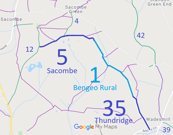
Map showing Sacombe 5 bridleway
Annotated map reproduced courtesy of Googlemaps.

We need a volunteer to photograph this route for this year's Access and Riding Rights of Way Survey. It's easy - just take photographs (safely) when you use the path. Find out more!

Legal History
1843: Part of Bengeo Rural 1 is shown on the Bengeo tithe map coloured ochre.
2 Feb 1953: Sacombe 5 was recorded as a bridleway on the original definitive map and statement. DM sheet DM2-11.
31 Dec 1977: Sacombe 5 was shown as a bridleway on the special review draft map and statement. DM sheet SR-45.
Definitive Statement (4 Dec 2015)
Path: [Sacombe] 5.  Recorded Status: Bridleway.  Definitive Map sheet: 45
Commences from parish boundary SW of its junction with Sacombe Green - High Cross Road thence W through Low Wood to N at Sacombe House to join BR12 at Sacombebury.

Statement should expressly refer to junction with Bengeo Rural 1.

Path: [Bengeo Rural] 1.  Recorded Status: Bridleway.  Definitive Map sheets: 45 and 46
Commences at junction with BR5 (Sacombe Park) at parish boundary between Home Wood and Low Wood thence SE through Cold Harbour Wood and Furzeground Wood to parish boundary and junction with BR35 in Thundridge parish.

Path: [Thundridge] 35.  Recorded Status: Bridleway.  Definitive Map sheets: 46
Commences from parish boundary at junction with BR1 (Bengeo) thence SE to county road SW of Rennesley.

Maintainability
This route is maintainable at the public expense because it was a footpath or bridleway existing before 30 Apr 1959.

© 2024 Patchetts Green Bridleways Trust.

Stats2