| Paths Greenways Bridleways Tracks | ||
| PG: OBJECTS: PROMOTION: Standon 92 - A10 underpass | ||
| We're collecting user evidence for the council now: Download user evidence form - Read the Instructions | ||
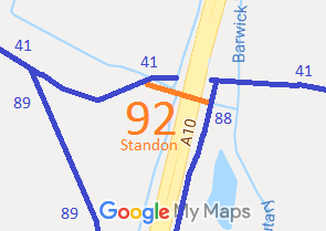
![]() Annotated map reproduced courtesy of Googlemaps. |
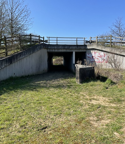
When the current A10 was constructed bridleway Standon 41 was cut in half. An underpass was put in and this has been used by walkers cyclists and some riders. Other riders have used bridleways 89 and 88 to use an alternative underpass to the south, which has more headroom, but is shared with motor vehicles.
This short path joins Standon 41 bridleway, under the A10, to Standon 88 bridleway, which leads to the other half of Standon 41. Although it is used as a bridleway, it is only recorded as a footpath, so we are collecting user evidence to correct the official record. |
![]()
A10 underpass |
||
If you have ridden the route, please download a user evidence form and then follow the instructions and return the form to us. It only takes a few minutes to fill in (the whole form fits on one side of a piece of A4 paper). If you have any other questions, please email us.
| ||||
| Legal History 1993: The A10 Trunk Road (Wadesmill, High Cross and Colliers End Bypass and Slip Road) Side Roads Order 1993 Schedule 5 (Route E) created this route in the underpass but did not make sure it joined the existing recorded bridleway (Standon 41) west of the A10. |
Definitive Statement (4 Dec 2015)
Path: [Standon] 92. Recorded Status: Footpath. Definitive Map sheet: 32 Commences at a junction with Standon Bridleway 88 at TL 3743 2045 then generally west, under the A10, for approximately 70 metres to TL 3735 2047. Width: 3.3 metres through the underpass Limitations: None |
© 2024 Patchetts Green Bridleways Trust. File reference: EC1151.