Paths Greenways Bridleways Tracks
 PG: OBJECTS: PROMOTION: Stevenage: Beehive Way to Tatlers Lane and track (Stevenage Boundary Route)
Stevenage Horse and Pony Route: Last: Path to rear of Walnut Tree Close Next: (To be continued)  SHPR 
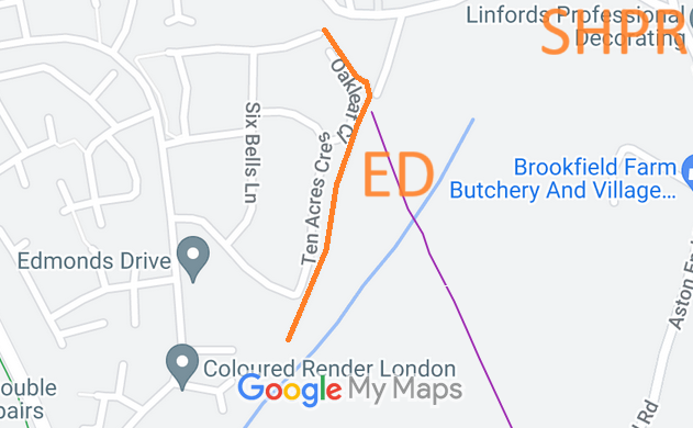
Map showing recorded Stevenage paths
Annotated map reproduced courtesy of Googlemaps.
This page is still being prepared.

A volunteer has photographed this route for the 2024 Access and Riding Rights of Way Survey, and the page will be updated shortly. Find out more!

At the time of the 2024 Access Survey (30 Jun 24), no gates were across the path and it was accessible all the way south to Gresley Way. There were no signposts.

BHS PGBT Although the route is physically open and available for riders, the Patchetts Green Bridleways Trust and British Horse Society, both desiring to complete the Stevenage Horse and Pony Route, were working to get this path properly recorded. An approach was made to the Stevenage Borough Council as landowner and the Hertfordshire County Council as highway authority, and both agreed to the creation of this route as a public bridleway maintainable at public expense. On 23 July 2026, the public path creation agreement was fully signed and sealed, and so the bridleway legally came into being. It will be recorded by means of a Legal Event Modification Order.

Legal History
8 Dec 2004: This route is described as part of the proposed Stevenage Horse and Pony Route on the Stevenage Local Plan map.
3 Jul 2024: Land ownership check: INSPIRE 36311201. Title HD182386. Register and Plan obtained. Charges register refers to bridlepath.
29 Jul 2024: Land ownership check: INSPIRE 36318800. Title HD202493. Register obtained. Charges register refers to bridlepath.
29 Jul 2024: Land ownership check: INSPIRE 59749945. Title HD573335. Register and Plan obtained. Owner is Stevenage Borough Council.
29 Jul 2025: Agreement in principle from Hertfordshire County Council to enter into a public path creation agreement to record the route.
3 Nov 2025: Agreement in principle from Stevenage Borough Council to enter into a public path creation agreement to record the route.
15 Nov 2025: Draft public path creation agreement sent to Hertfordshire County Council for consideration.
23 Jul 2026: Public path creation agreement between Stevenage Borough Council and Hertfordshire County Council made and came into effect.
Draft Definitive Statement (23 Jul 2026)
Path: [Stevenage] Awaited.  Status: Bridleway.  Definitive Map sheet: 30
Section commences from a junction with Six Bells Lane (public road) at TL 2710 2386 thence north-north-west for approximately 10 metres to a point south-south-west of Tatlers Lane (public road 3U53) at TL 2711 2388.
Section commences from TL 2710 2387 then generally south-east for approximately 70 metres to TL 2715 2381 then continuing generally south-south-west for approximately 235 metres to Stevange Borough Council's land boundary at TL 2708 2358.
Width: 4 metres
Limitations: None

© 2026 Patchetts Green Bridleways Trust. File reference: EC1063.

Stats2