| Patchetts Green Bridleways Trust | ||
| PG: OBJECTS: PROMOTION: St Stephen 94 RB Hyde Lane | ||
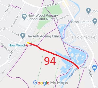
![]() Annotated map reproduced courtesy of Googlemaps. |
Hyde Lane is an old road, which used to run from Park Street to Park Street Lane. The part that crossed the railway was stopped up reserving footpath rights by the British Railways Act 1966. The rest of the route may
appear to be a cul-de-sac for riders, but it is planned that it will form part of a linking route between Moor Mill and Park Street Lane. The recording application was made to ensure that the route is safeguarded while the negotiations take place with adjoining landowners for the rest of the planned riding routes in the vicinity. We need a volunteer to photograph this route for this year's Access and Riding Rights of Way Survey. It's easy - just take photographs (safely) when you use the path. Find out more! |
| Legal History 17 Feb 2003: Application made to record route. 14 Feb 2011: The Hertfordshire County Council (St Stephen 94) Modification Order 2011, confirmed by the Council 13 Jan 2012, added this route to the definitive map as a footpath over the former level crossing, and restricted byway for the rest of its length. |
Definitive Statement (25 Aug 2011)
Path: [St Stephen] 94. Status: Restricted Byway Hyde Lane. Commences as FP from Hyde Lane public road at TL 1445 0341 running SE for approx. 10m across level crossing to TL 1446 0341. Continues as RB SE for approx 670m passing junctions with FPs 33, 33a, 26 and 35a, across ford at River Ver adjacent to the footbridge to join Hyde Lane public road at TL 1504 0312. Width: Varies between 3 and 12 metres as shown on the Order Plan forming part of the Hertfordshire County Council (St Stephen 94) Modification Order 2011. Limitations: Kissing gates at TL 1445 0341 and TL 1446 0341. |
|
Location Information
Postcode for SATNAV for anyone inspecting path: AL2 2LE (Hyde Lane Car Park). |
© 2024 Patchetts Green Bridleways Trust. File reference: EC349.