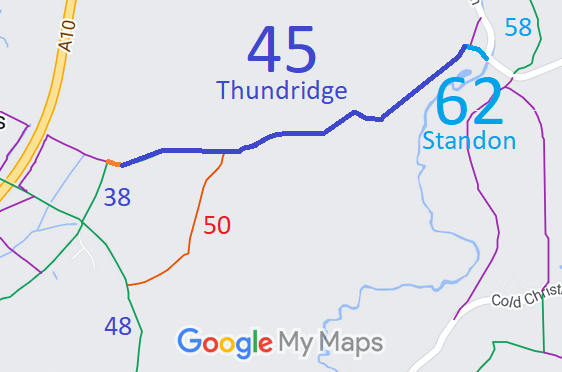
Annotated map reproduced courtesy of Googlemaps.
We need a volunteer to photograph this route for this year's Access and Riding Rights of Way Survey. It's easy - just take photographs (safely) when you use the path. Find out more!
| Paths Greenways Bridleways Tracks | ||
| PG: OBJECTS: PROMOTION: Thundridge 45 and Standon 62 | ||
Annotated map reproduced courtesy of Googlemaps. |
Thundridge 45 bridleway starts from the northern end of Thundridge 38 bridleway and continues generally eastwards and north-eastwards to become Standon 62 at the parish boundary. It then continues southeastwards to end on Barwick Road (public road).
We need a volunteer to photograph this route for this year's Access and Riding Rights of Way Survey. It's easy - just take photographs (safely) when you use the path. Find out more! |
| Legal History Nov 1846: Shown as public bridleway owned by Surveyor of Highways in Eastern Counties Railway (Cambridge Royston and Ware Line) Plan deposited with Parliament. 2 Feb 1953: Standon 60 was recorded as part bridleway part footpath on the original definitive map and statement. DM sheet DM2-14 (Herts 22 SW). When the parish boundary moved, most of Standon 60 was renamed as Thundridge 45. 23 Nov 1995: The Hertfordshire County Council (Thundridge 45 (part) and Standon 62) Modification Order 1995 (confirmed 5 Oct 1998, FPS/M1900/7/16) upgraded the footpath part of Thundridge 45 and added Standon 62 as a bridleway. 23 Jun 2023: Application made to record the section of Thundridge 45 FP from Thundridge 38 BW to Thundridge 45 BW as a bridleway. HCC reference EH/529. |
Definitive Statement (4 Dec 2015)
Path: [Thundridge] 45. Status: Bridleway / Footpath. Definitive Map sheet: 46 Commences as a FP from High Road at High Cross N of St. John's church thence SE to the western boundary of the A10 and a junction with Thundridge FP56 at TL 3679 1855. Recommences at the eastern boundary of the A10 and a junction with Thundridge FP 59 at TL 3687 1852 and continues SE to Great Southey Wood and junction with BR 39. Changes to a BR runs SE to NW corner of Round Wood (TL 3756 1847). Follows the northern edge of Round Wood for a distance of approx. 170m (to TL 3773 1853) thence E for a distance of approx. 240m (to TL 3796 1856) thence NE for a distance of approx. 150m to corner of Tyler's Hill (TL 3808 1864). Follows S side of drain for a distance of approx. 110m (to TL 3819 1862) thence NE for a distance of approx. 440m to the parish boundary at Great Barwick and its junction with Standon 62 BR (TL 3851 1891). Width: 3m Limitations: None Statement says it changes to a BW at jn with BR 39, but webmap shows FP for a short distance before it changes to BW. Path: [Standon] 62. Status: Bridleway.
Definitive Map sheet: 46 |
© 2023 Patchetts Green Bridleways Trust.
File references: EC036 and EC1187.
HCC reference: EH/529.
