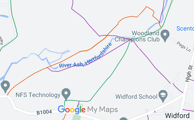
Annotated map reproduced courtesy of Googlemaps.
We need a volunteer to photograph this route for this year's Access and Riding Rights of Way Survey. It's easy - just take photographs (safely) when you use the path. Find out more!
| Paths Greenways Bridleways Tracks | ||
| PG: OBJECTS: PROMOTION: Wareside 84 RB and Widford 13, 18 and 26 RB | ||
Annotated map reproduced courtesy of Googlemaps. |
This page is still being prepared.
We need a volunteer to photograph this route for this year's Access and Riding Rights of Way Survey. It's easy - just take photographs (safely) when you use the path. Find out more! |
|||
| Legal History 1 Jul 2011: The Hertfordshire County Council (Widford 13, 18, 26 and Wareside 84) Modification Order 2011 (confirmed 14 Jun 2017) modified the definitive map and statement to record these routes correctly. |
Definitive Statement (9 Mar 2011)
Path: [Wareside] 84. Status: Restricted Byway. Definitive Map sheet: 47 Commences from junction with Widford RB18 on the parish boundary at TL 4131 1616 then generally NE following the parish boundary for approximately 220 metres parallel with Widford RB18 to the junction with Widford FP18 and Wareside FP16 at TL 4149 1628, then continues generally north east along the parish boundary for approximately 100 metres parallel with Widford RB26 to TL 4156 1635 where it joins Widford RB26. Width: 1.5 metres between TL 4131 1616 and TL 4156 1635 being the Wareside moiety of the route as shown on the plan forming part of the Hertfordshire County Council (Widford 13, 18, 26 and Wareside 84) Modification Order 2011. Limitations: None Path: [Widford] 26. Status: Restricted Byway.
Definitive Map sheet: 47 Path: [Widford] 18. Status: Restricted Byway and Footpath.
Definitive Map sheet: 47 Path: [Widford] 13. Status: Restricted Byway and Footpath.
Definitive Map sheet: 47 |
© 2023 Patchetts Green Bridleways Trust.
