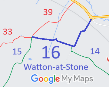
Annotated map reproduced courtesy of Googlemaps.
We need a volunteer to photograph this route for this year's Access and Riding Rights of Way Survey. It's easy - just take photographs (safely) when you use the path. Find out more!
| Paths Greenways Bridleways Tracks | ||
| PG: OBJECTS: PROMOTION: Watton-at-Stone 16 | ||
Annotated map reproduced courtesy of Googlemaps. |
This page is still being prepared.
We need a volunteer to photograph this route for this year's Access and Riding Rights of Way Survey. It's easy - just take photographs (safely) when you use the path. Find out more! |
| Legal History |
Definitive Statement (4 Dec 2015)
Path: [Watton at Stone] 16. Status: Bridleway. Definitive Map sheet: 44 Commences at parish boundary and junction with Watton-at-Stone Restricted Byway 39 at TL 2823 1975 by Stocking Grove thence E to junction with BR14 by Broom Hall Farm thence NE across railway to junction with county road at the roundabout at the western end of the Watton Bypass at TL 2899 1998. |
© 2021 Patchetts Green Bridleways Trust.
