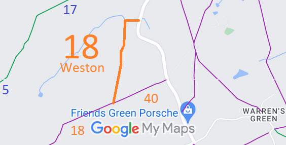
Annotated map reproduced courtesy of Googlemaps.
| Paths Greenways Bridleways Tracks | ||
| PG: OBJECTS: PROMOTION: Weston 18 (part) (recorded FP and applied-for BW) | ||
| We're collecting user evidence for the council now: Download user evidence form - Read the Instructions | ||
Annotated map reproduced courtesy of Googlemaps. |
This route starts from the junction of Weston 18 and Weston 40 (footpaths with bridleway status applied for) and continues generally northeastwards to Damask Green Road, Weston (public road). | |||
| If you have ridden the route, please download a user evidence form and then follow the instructions and return the form to us. It only takes a few minutes to fill in (the whole form fits on one side of a piece of A4 paper). If you have any other questions, please email us. | ||||
| Legal History 27 Jan 2024: Application to record route as a bridleway. HCC reference NH/353. |
Definitive Statement (4 Dec 2015)
Path: [Weston] 18. Recorded Status: Footpath. Definitive Map sheet: 22 Commences from Weston - Stevenage Road approx. 1/4 mile SW of entrance to The Park at S end of Damask Green, thence W past Paddock thence S SW to join FP40 thence SW to join FP9 (Graveley) at parish boundary E of Stonesley Wood. |
© 2024 Patchetts Green Bridleways Trust.
File reference: EC1079.
DOBBIN reference: HER-0115.
HCC reference: NH/353.
