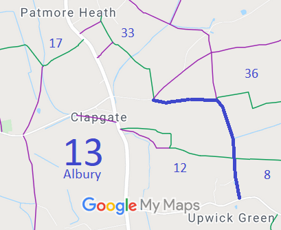
Annotated map reproduced courtesy of Googlemaps.
We need a volunteer to photograph this route for this year's Access and Riding Rights of Way Survey. It's easy - just take photographs (safely) when you use the path. Find out more!
| Paths Greenways Bridleways Tracks | ||
| PG: OBJECTS: PROMOTION: Albury 13 | ||
Annotated map reproduced courtesy of Googlemaps. |
This route starts on Mill Lane (public road), near Albury 33 bridleway
and continues generally east to a junction with Albury 36 bridleway then south to join the public road at Upwick Green.
We need a volunteer to photograph this route for this year's Access and Riding Rights of Way Survey. It's easy - just take photographs (safely) when you use the path. Find out more! |
| Legal History 19 Dec 2003: The Hertfordshire County Council (Albury 13) Modification Order 2003 (confirmed 25 Mar 2010) added part of this route and upgraded a footpath to bridleway. 21 Dec 2007: The Hertfordshire County Council (Albury 13) Diversion Order 2007 (confirmed 25 Mar 2010) diverted part of this route (from one side of field boundary to the other). |
Definitive Statement (4 Dec 2015)
Path: [Albury] 13. Status: Bridleway. Definitive Map sheets: 33 and 34 Commences from Mount Pleasant, Mill Lane thence E along S side of hedge for approximately 445m to junction with Albury 13a at TL 4501 2497 thence S past E boundary of Salmon Mead Spring for 700m to county road at Upwick Green at TL 4519 2430. Width: 4 metres between TL 4457 2496 and TL 4499 2497. Varying between 3 and 6 metres between TL 4499 2497 and TL 4501 2497. Varying between 3 and 4 metres between TL 4501 2497 and TL 4519 2430. Limitations: None Stated junction with FP13A should really be to BW 36. |
© 2022 Patchetts Green Bridleways Trust.
File reference: EC210.
