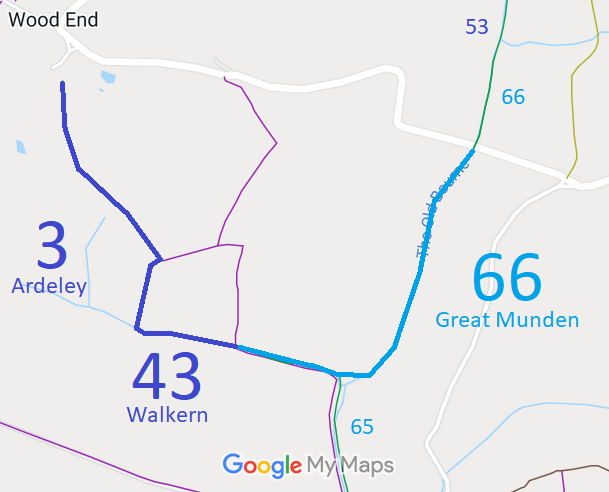
Annotated map reproduced courtesy of Googlemaps.
We need a volunteer to photograph this route for this year's Access and Riding Rights of Way Survey. It's easy - just take photographs (safely) when you use the path. Find out more!
| Paths Greenways Bridleways Tracks | ||
| PG: OBJECTS: PROMOTION: Ardeley 3, Walkern 43 and Great Munden 66 | ||
Annotated map reproduced courtesy of Googlemaps. |
This page is still being prepared.
We need a volunteer to photograph this route for this year's Access and Riding Rights of Way Survey. It's easy - just take photographs (safely) when you use the path. Find out more! |
| Legal History 1839: Ardeley 3 and Great Munden 66 were shown on the Ardeley tithe map as not subject to an apportionment. 31 Dec 1977: Ardeley 3 was shown as a bridleway on the special review draft map and statement. DM sheet SR-23 (TL32NW). 20 Jan 2012: The Hertfordshire County Council (Ardeley 3, 52 and 53, Great Munden 65, 66 and 67 and Walkern 43) Modification Order 2012 (confirmed 21 February 2017) recorded this route in more detail on the definitive map and statement as a bridleway. Planning Inspectorate reference FPS/M1900/7/81. |
Definitive Statement (3 Jan 2012 (confirmed 21 Feb 2017))
Path: [Ardeley] 3. Status: Bridleway. Definitive Map sheet: 23 and 31 Commences at the public road east of Cherry Farm, Wood End at TL 3260 2539 and continues generally SW, SE and S for approx. 770m across Wood End Green, along Lye Lane and Little Lye Grove to join Walkern RB 43 at TL 3275 2474, then continues E along the Old Bourne parallel to Wlakern RB 43 for approx. 240m, to junction with Ardeley FP 26 and Ardeley RB 52 at TL 3299 2470. Width: Varies between 6 metres and 42 metres between TL 3260 2539 and TL 3275 2472 as shown shaded grey on Part 2 of the Order Plans forming part of the Hertfordshire County Council (Ardeley 3, 52 and 53, Great Munden 65, 66 and 67 and Walkern 43) Modification Order 2012. Varies between 5 metres and 15 metres between TL 3275 2472 and TL 3299 2470 being the Ardeley moiety of the route as shown shaded grey on Parts 2 and 3 of the Order Plans forming part of the Hertfordshire County Council (Ardeley 3, 52 and 53, Great Munden 65, 66 and 67 and Walkern 43) Modification Order 2012. Limitations: None Path: [Walkern] 43. Status: Bridleway.
Definitive Map sheet: 23 and 31 |
© 2022-2026 Patchetts Green Bridleways Trust.
File reference: EC389. HCC reference EH/284.
