Legal History
The numbering of paths in Bishop's Stortford before 2000 was unlike that in the rest of Hertfordshire!
2 Feb 1953: Bishop's Stortford 8 was recorded as CRF (Carriage Road used as a Footpath) N1 on the original definitive map and statement. DM sheet DM1-20 (Herts 23 NW).
25 Feb 1975: The County Council of Hertfordshire Bishops Stortford North West By-Pass (Side Roads) Order 1975 (confirmed 14 Oct 1975) diverted the part of the CRF over the A120. The replacement route was created as a road. (This status is not shown on the definitive map in 2015.)
31 Dec 1977: The route was shown as a bridleway on the special review draft map and statement. The diversion caused by the 1975 order was not shown at this point. DM sheet SR-34.
13 Mar 2015: The Hertfordshire County Council (Bishop's Stortford 8 & 9) Legal Event Modification Order 2015 updated the definitive map and statement by removing a section of Bishop's Stortford 9 BW that had been stopped up in 1975 and adding the ‘bridge’ section of Bishop's Stortford 8 that had been created in 1975.
22 Dec 2022: HCC Temporary Traffic Regulation Order preventing use of southern end while utilities works take place.
20 Nov 2025: The Hertfordshire County Council (Bishops Stortford 8) Public Path Creation Order 2025, made 20 Nov 2025 and confirmed 5 Feb 2026, created bridleway rights from the former end point of Bishops Stortford 8 bridleway southwards to Hadham Road and recorded this extension with a width varying between 5m and 7m.
...
|
|
Definitive Statement (4 Dec 2015)
Path: [Bishop's Stortford] 8. Status: Bridleway.
Definitive Map sheet: 34
BR8 to Wickham Hall and Upwick. From junction with FP7 runs due north, under the Bishop’s Stortford By-Pass (A120), to a junction with Bishop’s Stortford Bridleway 9 at TL 4735 2269. Then continues N to Wickham Hall. Passes to east immediately in front of house to end of orchard and continues north outside the district boundary.
Width: 5m between TL 4736 2247 and TL 4735 2269
Limitations: None between TL 4736 2247 and TL 4735 2269
|
Maintainability
The route from Bishop s Stortford 74 to Bishop s Stortford 7 footpath is maintainable at the public expense because it was a footpath or bridleway existing before 30 Apr 1959.
The route from Bishop s Stortford 7 footpath to Hadham Road is maintainable at the public expense by virtue of s.36(2)(d) Highways Act 1980. [Public Path Creation Order]
|
|
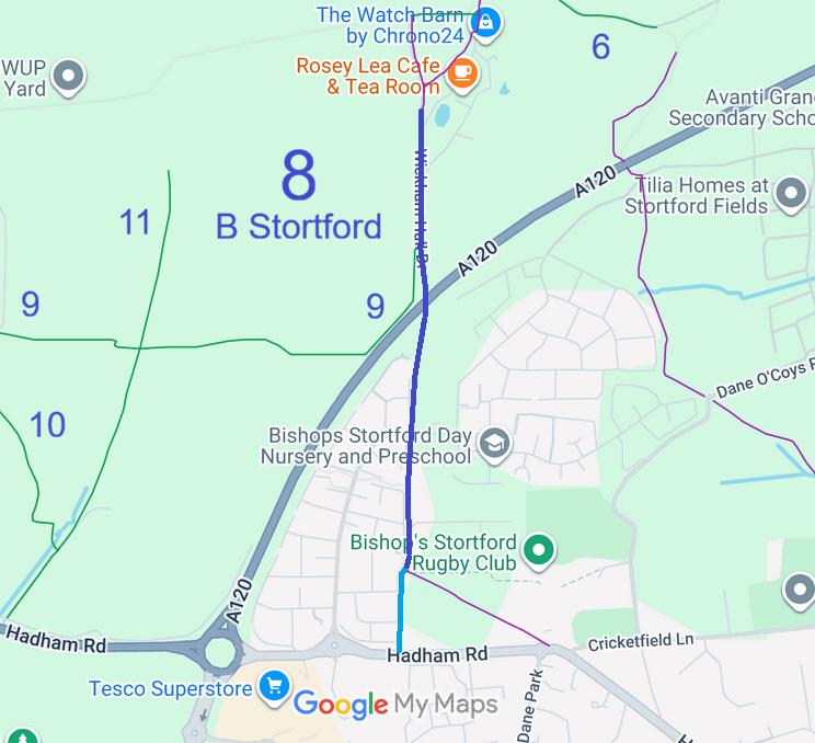


 Bishops’s Stortford 8 bridleway used to end at its junction with Bishop’s Stortford 7 footpath. By having the right discussions when the housing was being extended southwards and footpath 7 was being diverted, it was found that there was agreement for legal creation of a bridleway route through to Hadham Road. The British Horse Society and the Patchetts Green Bridleways Trust thank the County Council for making the creation order needed to legally record the extra length of bridleway, shown in pale blue on the plan.
