| Paths Greenways Bridleways Tracks | ||
| PG: OBJECTS: PROMOTION: Codicote 25 BW and Hogsnorton Lane | ||
| We're collecting user evidence for the council now: Download user evidence form - Read the Instructions | ||
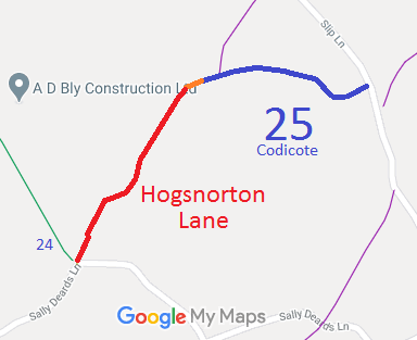
![]() Annotated map reproduced courtesy of Googlemaps. |
Hogsnorton Lane starts on Sally Deards Lane by Codicote 24 bridleway. It heads generally northeastwards to a junction with Codicote 25 bridleway which continues to Slip Lane (public road).
Hogsnorton Lane is not recorded on the definitive map. To assist the application, we would like some statements of users. If you have ridden the route at any point since since 2003, please see below. We need a volunteer to photograph this route for this year's Access and Riding Rights of Way Survey. It's easy - just take photographs (safely) when you use the path. Find out more! |
|||
If you have ridden the route, please download a user evidence form and then follow the instructions and return the form to us. It only takes a few minutes to fill in (the whole form fits on one side of a piece of A4 paper). If you have any other questions, please email us.
| ||||
| Legal History 1938: Codicote 25 is shown as a green lane (green dots) and the rest of the route is shown as a class 3 road on the Hertfordshire County Council ROW survey. Map: Hitchin Rural West 19 (Herts 20 SE). 1 Nov 1953: Codicote 25 was recorded as a bridleway on the original definitive statement. DM sheet DM4-43. 10 Jan 2003: Hogsnorton Lane was diverted to its current alignment under s.116 Highways Act by Magistrates on the application of Hertfordshire County Council. 21 Mar 2021: Application made to record whole route, including the gap. HCC reference NH/336 (ROW) and DZ 91 (Legal).
|
Definitive Statement (4 Dec 2015)
Path: [Codicote] 25. Status: Bridleway. Definitive Map sheet: 43 Commences from end of county road NE of Hogsnorton thence E to join Rabley Heath - Knebworth road. |
© 2024 Patchetts Green Bridleways Trust. File reference: EC362.