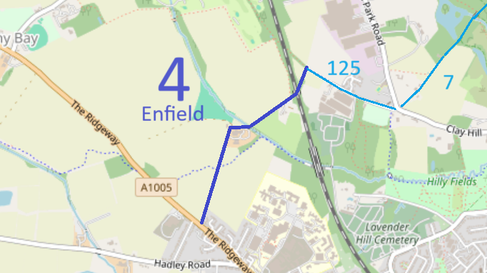
Map data from © OpenStreetMap and Enfield London Borough Council.
We need a volunteer to photograph this route for the Access and Riding Rights of Way Survey. It's easy - just take photographs (safely) when you use the path. Find out more!
| Paths Greenways Bridleways Tracks | ||
| PG: OBJECTS: PROMOTION: Enfield 4 | ||
Map data from © OpenStreetMap and Enfield London Borough Council. |
This way starts at The Ridgeway (public road) and continues generally northeastwards to end at a junction with Enfield 125 bridleway (Strayfield Road).
We need a volunteer to photograph this route for the Access and Riding Rights of Way Survey. It's easy - just take photographs (safely) when you use the path. Find out more! |
|||
| Legal History 1 Aug 1953: Enfield 4 was shown as a bridleway on the draft map for Middlesex. Map sheet Middx 2 SW (Herts 41 SW). 31 Dec 1974: Enfield 4 was shown as a bridleway in the review map and statement for LB Enfield. Map Sheet: Middx 2.br> |
Enfield Definitive Statement (28 Nov 2020)
Path: [Enfield] 4. Status: Bridleway. The path commences at the junction of path No. 3 at Strayfield Road. Bear S.W. along a lane. Passes under railway bridge to house on left hand side. Cross over stream by cart bridge, bear round N.W. side of Rectory Farm, past farm buildings on left to two gate posts by house. From here to The Ridgeway, tarmacadam road. Exit to The Ridgeway through wide gap |
© 2025 Patchetts Green Bridleways Trust.
