Paths Greenways Bridleways Tracks
 PG: OBJECTS: PROMOTION: Great Amwell 18
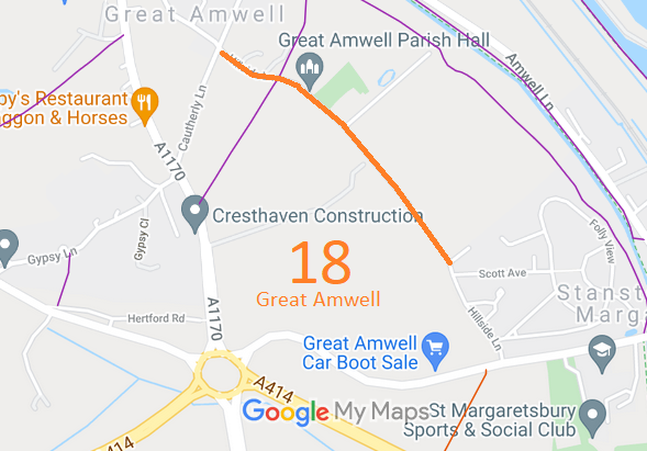
Map showing recorded Great Amwell paths
Annotated map reproduced courtesy of Googlemaps.
This route runs generally southeastwards between two sections of Hilside Lane.

We need a volunteer to photograph this route for this year's Access and Riding Rights of Way Survey. It's easy - just take photographs (safely) when you use the path. Find out more!

Legal History
1839: Great Amwell 18 is shown on the Great Amwell tithe map as not subject to an apportionment.
1910: Route shown excluded from valuation on the Inland Revenue survey. IR 126/4/249.
2 Feb 1953: The route was recorded as a footpath on the original definitive map and statement. DM sheet DM2-26 (Herts 30 SW).
31 Dec 1977: The route was shown as a footpath on the special review draft map and statement. DM sheet SR-60 (TL31SE).
9 May 2016: Application to record as restricted byway. HCC reference EH/441.
Application Process
Path Application Certificate Direction Inv Report Order Confirmed
EC808 9 May 2016 EH/441 31 May 2016        
Definitive Statement (4 Dec 2015)
Path: [Great Amwell] 18.  Recorded Status: Footpath.  Definitive Map sheet: 60
Commences at County Road S of Warehill House thence SE across FP12 past village hall to join Hillside Lane.
Maintainability
This route is currently maintainable at the public expense because it was a footpath or bridleway existing before 30 Apr 1959.
(But we believe that) This route is maintainable at the public expense because it was a highway before 1835.

© 2024 Patchetts Green Bridleways Trust. File reference: EC808.

Stats2