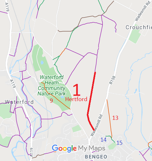
Annotated map reproduced courtesy of Googlemaps.
We need a volunteer to photograph this route for this year's Access and Riding Rights of Way Survey. It's easy - just take photographs (safely) when you use the path. Find out more!
| Paths Greenways Bridleways Tracks | ||
| PG: OBJECTS: PROMOTION: Hertford 1 RB, 1 FP, 2 FP and Bengeo Rural 14 FP | ||
Annotated map reproduced courtesy of Googlemaps. |
This page is still being prepared.
We need a volunteer to photograph this route for this year's Access and Riding Rights of Way Survey. It's easy - just take photographs (safely) when you use the path. Find out more! |
| Legal History 2 May 2006: Restricted Byway rights were confirmed or created on part of Hertford 1 by virtue of ss 47 and 48 Countryside and Rights of Way Act 2000. 30 Apr 1993: Application to upgrade Hertford 1, 2, 6 and 7 FP and Bengeo Rural 12 and 14 FP to bridleway. HCC reference EH/36/MOD. 15 Jun 2012: HCC decided that there was insufficient evidence to upgrade Hertford 1 and 2 FP and Bengeo Rural 14 FP. |
Definitive Statement (4 Dec 2015)
Path: [Hertford] 1. Recorded Status: Footpath / Restricted Byway. Definitive Map sheet: 45 and 59 To Chapman End. Starts as a Restricted Byway from Wadesmill Road by Glenholm Cottage, follows line of hedgerow on left passes through open field crosses the old municipal Borough Boundary follows hedgerow on right to end of field. Path becomes less clearly defined as it rises uphill, through centre of field where it changes to a FP opposite the Electricity Sub Station, it then passes into St John's Wood downhill to centre of wood and meeting of footpaths. Path: [Hertford] 2. Recorded Status: Footpath.
Definitive Map sheet: 45 Path: [Bengeo Rural] 14. Recorded Status: Footpath.
Definitive Map sheet: 45 |
© 2021 Patchetts Green Bridleways Trust.
File reference: EC097, EC133, EC340.
