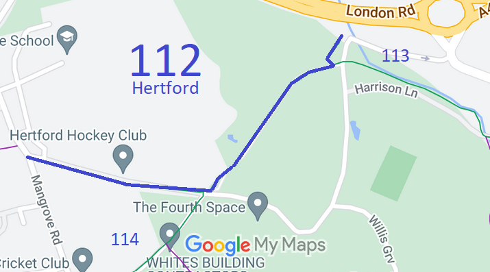
Annotated map reproduced courtesy of Googlemaps.
We need a volunteer to photograph this route for the Access and Riding Rights of Way Survey. It's easy - just take photographs (safely) when you use the path. Find out more!
| Paths Greenways Bridleways Tracks | ||
| PG: OBJECTS: PROMOTION: Hertford 112 | ||
Annotated map reproduced courtesy of Googlemaps. |
This bridleway starts from Mangrove Road (public road) and continues generally eastsoutheastwards to a junction with Hertford 114 bridleway then turns northeastwards to a junction with Hertford 113 bridleway before ending on the (old part of) London Road.
We need a volunteer to photograph this route for the Access and Riding Rights of Way Survey. It's easy - just take photographs (safely) when you use the path. Find out more! |
|||
| Legal History 5 Aug 2016: The Simon Balle School Publc Path Creation Agreement 2015 added some paths. 27 Feb 2017: The Balls Park Public Path Creation Agreement 2014 added some paths. 18 Aug 2017: The Hertfordshire County Council (Balls Park, Hertford) Legal Event Modification Order 2017 added the paths from the two creation agreements to the definitive map and statement. |
Definitive Statement (15 Mar 2017)
Path: [Hertford] 112. Status: Bridleway. Definitive Map sheet: 59 Commences from Mangrove Road (public road) at TL 3315 1210 then runs ESE following access road for approx 255m to join BR114 at TL 3340 1206. Continues NW following NE boundary of the Park for approx 270m to join BR113 at TL 3358 1224 then continues NW and NE for approximately 50m adjacent to the access road at Red Lodge to join London Road (public road) at TL 3359 1228. Width: 3 metres Limitations: Gap of 1.8 metres at TL 3318 1209 |
© 2023 Patchetts Green Bridleways Trust.
