Paths Greenways Bridleways Tracks
 PG: OBJECTS: PROMOTION: Hoddesdon 25 and 26
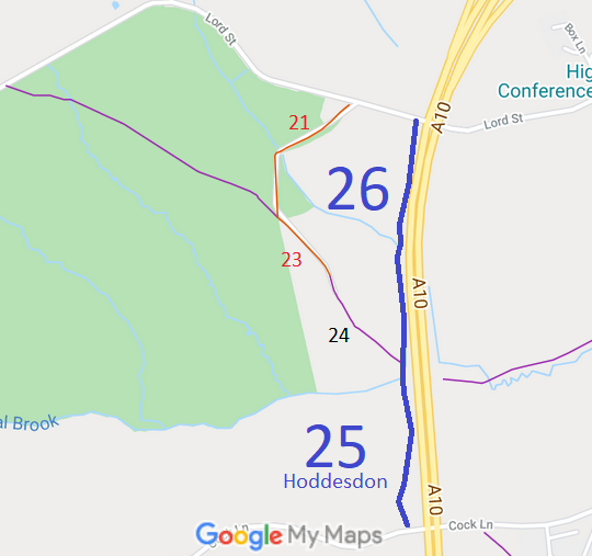
Map showing Hoddesdon 25 bridleway
Annotated map reproduced courtesy of Googlemaps.
This route starts from Lord Street (public road) and heads generally southwards to Cock Lane (public road).

We need a volunteer to photograph this route for this year's Access and Riding Rights of Way Survey. It's easy - just take photographs (safely) when you use the path. Find out more!

Legal History
4 Jul 1890: The Broxbourne and Hoddesdon Open Spaces and Recreation Grounds Act 1890 declared and defined these routes to be public bridleway (Bridleway 24).
12 Feb 1971: The London - Cambridge Trunk Road (Hoddesdon By-Pass, Side Roads) Order 1971 (which came into effect on 23 Feb 1971) diverted the route of Hoddesdon 25 and 26 bridleway to the present alignment.
Definitive Statement (4 Dec 2015)
Path: [Hoddesdon] 25.  Status: Bridleway.  Definitive Map sheet: 72
Commences at junction with Cock Lane, NE of Lodge, thence north parallel to by-pass (A10) to join BR26 and FP20 Spring Mead.

Path: [Hoddesdon] 26.  Status: Bridleway.  Definitive Map sheet: 72
Commences from Spring Mead thence in a northerly direction pass path to Hoddesdon Lodge (FP24) and FP20 path to Barclay's Park, crosses stream thence follows W boundary of fields, then along gravel track to Lord Street.

Maintainability
This route is maintainable at the public expense because it was a footpath or bridleway existing before 30 Apr 1959.

© 2025 Patchetts Green Bridleways Trust.

Stats2