Paths Greenways Bridleways Tracks
 PG: OBJECTS: PROMOTION: Little Munden 10 and Walkern 3A
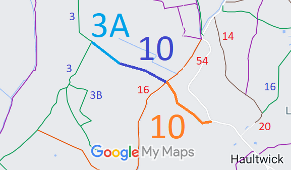
Map showing Little Munden and Walkern paths
Annotated map reproduced courtesy of Googlemaps.
The route starts on The Street (public road) and heads generally northwest to Little Munden 16 restricted byway and The Old Bourne, then continues as a bridleway to become Walkern 3A bridleway at the parish boundary then continues to end on Walkern 3 bridleway.

We need a volunteer to photograph this route for this year's Access and Riding Rights of Way Survey. It's easy - just take photographs (safely) when you use the path. Find out more!

BHS As part of the British Horse Society's work to record paths before Path Extinguishment Day, it was spotted that Little Munden 10 from The Street to Little Munden 16 restricted byway appeared to be an old road rather than a bridleway, so an application was made to record it as a restricted byway.

Legal History
18 Mar 2013: Application to record Little Munden 10 BW as RB. HCC reference EH/412.
Definitive Statement (4 Dec 2015)
Path: [Little Munden] 10.  Status: Bridleway.  Definitive Map sheet: 31
Commences at junction with county road NW of Haultwick Hall thence NW across Ford at The Old Bourne to parish boundary S of SW corner at Woodcroft Wood.

Statement should record junction with Walkern 3A

Path: [Walkern] 3A.  Status: Bridleway.  Definitive Map sheet: 31
Commences from BR3 W of Woodcroft Wood thence SE to parish boundary N of Shouts Wood.

Statement should record junction with Little Munden 10

© 2022 Patchetts Green Bridleways Trust. File reference: EC714.