Patchetts Green Bridleways Trust
 PG: OBJECTS: PROMOTION: WELWYN HATFIELD: North Mymms 2
London Orbital Bridleroute: Anti-clockwise: Ridge 10. Clockwise: St Mary's Church Road, Tollgate Road, North Mymms 82.  H25 
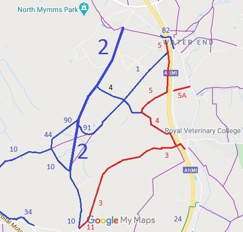
Map showing North Mymms 2 bridleway
Annotated map reproduced courtesy of Googlemaps.
This route runs from bridleway Ridge 10 to the county road near St Mary's Church.

It has junctions with bridleways North Mymms 90, North Mymms 91 and North Mymms 4.

We need a volunteer to photograph this route for this year's Access and Riding Rights of Way Survey. It's easy - just take photographs (safely) when you use the path. Find out more!

Legal History
Recorded as bridleway on the original (1953) definitive map.
Definitive Statement (4 Dec 2015)
Path: [North Mymms] 2.  Status: Bridleway.  Definitive Map sheet: 78
Commences from parish boundary at junction with BR10 (Ridge) N of South Lodge, North Mimms Park thence N along parish boundary to junction with FP1 at next lodge (this portion scheduled by Ridge as BR10) thence NE past Potwells and through Cangsley Grove past BR4 to the E of North Mimms Park thence to join end of county road leading to War Memorial Lodge E of St Mary's Church.

© 2024 Patchetts Green Bridleways Trust.