Patchetts Green Bridleways Trust
 PG: OBJECTS: PROMOTION: HERTSMERE: Ridge 10 and 13 BW
London Orbital Bridleroute: Anti-clockwise: Blackhorse Lane to Ridge 34. Clockwise: North Mymms 2.  H25 
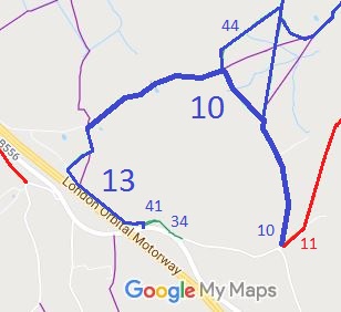
Map showing Ridge 10 and 13 bridleways
Annotated map reproduced courtesy of Googlemaps.
This route starts as bridleway Ridge 13 on the B556. It has a junction with Ridge 34 and Ridge 41, then runs roughly parallel to the M25 motorway before turning towards Redwell Wood Farm and a junction with bridleway Ridge 10.

The route continues as bridleway Ridge 10 generally NE to a junction with bridleway Ridge 44. It continues SE to a defined track which leads to Blackhorse Lane and a junction with restricted byway Ridge 11.

We need a volunteer to photograph this route for this year's Access and Riding Rights of Way Survey. It's easy - just take photographs (safely) when you use the path. Find out more!
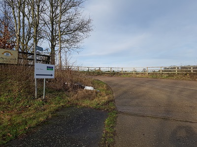
View from Ridge 13 from B556

View from B556
Photo: Phil Wadey, 6 Jan 2023

Legal History
Ridge 10 was recorded as bridleway on the original (1953) definitive map.
Ridge 13 was recorded as CRF (Carriage Road used as a Footpath) on the original (1953) definitive map.
The construction of the M25 motorway caused Ridge 13 to be diverted to its current alignment.
2 Jul 2010: The Redwell Wood Farm Public Path Creation Agreement 2010 added width to the southern end of Ridge 13.
22 Jul 2011: The Hertfordshire County Council (Ridge 13 and Ridge 41) Legal Event Modification Order 2011 recorded the extra width.
Definitive Statement (4 Dec 2015)
Path: [Ridge] 10.  Status: Bridleway.  Definitive Map sheet: 78
Commences at junction with FP8 N of Ridgehill Farm thence generally NE past N boundary of Redwell Wood thence SE from NE corner of wood to parish boundary near lodge thence generally S along parish boundary and through S part of Redwell Wood to junction with county road at parish boundary.

Path: [Ridge] 13.  Status: Bridleway.  Definitive Map sheet: 78
Commences at junction with county road B556 at TL 2100 0216 thence N for approx. 10m to a junction with BR34 at TL 2101 0217 and NW for approx. 40m to a junction with BR41 at TL 2097 0218 thence generally north-westwards alongside the M25 Motorway boundary past junction with FP12 to TL 2059 0247 thence NE and NW along lane to junction with BR10 NW of Ridgehill Farm.
Width: Varying between 5 metres and 15 metres between TL 2100 0217 and TL 2059 0246 as shown in The Redwell Wood Farm Public Path Creation Agreement 2010

© 2023 Patchetts Green Bridleways Trust. File reference: EC992 (for extra width on Ridge 13).