Legal History
2 May 2006: Restricted Byway rights were confirmed or created on this path by virtue of ss 47 and 48 Countryside and Rights of Way Act 2000.
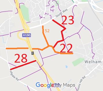
19 Aug 2008: Landowner deposit under s.31 Highways Act 1980 sets out North Mymms 22 and North Mymms 23 as ‘highways with at least bridleway rights which may have possible vehicular rights (Road Used as Public Path or RUPP).’
10 Jun 2025: Hertfordshire County Council Investigation report issued (as a ‘discovered evidence’ case). Decision awaited.
6 Jul 2026: Hertfordshire County Council issued a decision that the definitive map and statement were correct in respect of North Mymms 22 and 23, and the status remained RB.
1 Oct 2026: The Hertfordshire County Council (North Mymms 92 and North Mymms 93) Modification Order 2026 (confirmed 1 Oct 2026) altered the definitive statement for this way.
|
|
Definitive Statement (24 Mar 2026)
Path: [North Mymms] 22. Status: RB.
Definitive Map sheet: 69
Commences from North Mymms RB 92 (Dellsome Lane) NW of Dellsome Bottom thence NE to junction with FP45
and NW parallel with FP23 to junction with same.
Statement should also record junction with North Mymms 23 RB, for completeness.
Definitive Statement (4 Dec 2015)
Path: [North Mymms] 23. Status: FP/RB.
Definitive Map sheet: 69
Commences on southern side of A1001 as a Restricted Byway SE past FP21 to pond SW of School thence SW and S to junction with Restricted Byway 22. Continues along boundary of school site as a FP thence SE parallel with Restricted Byway 22 to a point opposite the commencement of FP45, thence NE along southern boundary of school site past FP23a to junction with FP20 E of school.
|
|