Legal History
1837: Welwyn 33 and part of Welwyn 34 were shown on the Welwyn tithe map as not subject to an apportionment.
1838: Tewin 38 was shown on the Tewin tithe map as not subject to an apportionment.
5 Dec 2016: Application to record route as restricted byway. HCC references WH/109, WH/110 and EH/451.
21 Oct 2019: Landowner deposit in respect of short section on Danecroft Riding Stables' land, only admitting FP status.
8 Jul 2023: Applied for a direction that the county council determine the application by a set date. PINS reference ROW/3325631.
15 Jan 2024: Secretary of State directed Hertfordshire County Council to determine the application by 15 Jul 2024. PINS reference ROW/3325631.
10 Feb 2026: Hertfordshire County Council Investigation report issued. Decision awaited.
| Application Process |
| Path |
Application |
Certificate |
Direction |
Inv Report |
Order |
Confirmed |
| EC743 |
5 Dec 2016 WH/109 &c |
21 Jun 2017 |
15 Jan 2024 (6mo) |
10 Feb 2026 |
|
|
|
|
Definitive Statement (4 Dec 2015)
Path: [Welwyn] 33. Recorded Status: Footpath.
Definitive Map sheet: 44
Commences from Tewin parish boundary S of Village Hall thence SW along southern
boundary of Burnham Wood to join FP34 at reservoir.
Path: [Welwyn] 34. Recorded Status: Footpath.
Definitive Map sheet: 44
Commences from county road at Works thence generally SW to junction with BR36 east of
Harmergreen House. Then from BR50 south west to join county road again at Digswell Vale.
Path: [Tewin] 38. Recorded Status: Footpath.
Definitive Map sheet: 44
Commences at Burnham Green S of Mission Chapel thence SW to parish boundary and
junction with FP33 (Welwyn parish).
|
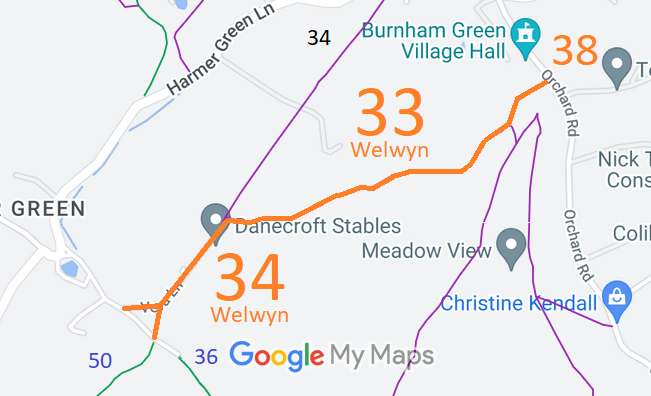
 As part of the British Horse Society's work to record paths before
Path Extinguishment Day,
it was spotted that the historical evidence showed a continuous route as an old road, so an application was made in 2016 to record it as a restricted byway.
