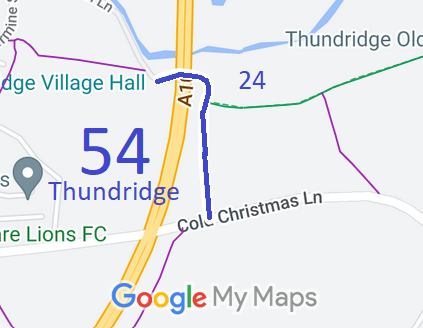
Annotated map reproduced courtesy of Googlemaps.
We need a volunteer to photograph this route for this year's Access and Riding Rights of Way Survey. It's easy - just take photographs (safely) when you use the path. Find out more!
| Paths Greenways Bridleways Tracks | ||
| PG: OBJECTS: PROMOTION: Thundridge 54 | ||
Annotated map reproduced courtesy of Googlemaps. |
This route starts from Old Church Lane, Thundridge, and continues eastwards, under the A10 trunk road to a junction with Thundridge 24 bridleway, then continues southwards to Cold Christmas Lane (public road).
We need a volunteer to photograph this route for this year's Access and Riding Rights of Way Survey. It's easy - just take photographs (safely) when you use the path. Find out more! |
| Legal History |
Definitive Statement (4 Dec 2015)
Path: [Thundridge] 54. Status: Bridleway. Definitive Map sheet: 46 Commences at a junction with Cold Christmas Lane at TL 3631 1693 and continues generally north for approx 230m to a junction with Thundridge BR24 at TL 3630 1716, continuing generally north for approx 50m to TL 3630 1720 then west, passing under the A10, for approx 110m to a junction with Old Church Lane at TL 3620 1720. The bridleway between TL 3630 1712 and its junction with Old Church Lane at TL 3620 1720 is coexistent with a private means of access (which includes vehicular rights). Width: 2.5 metres between TL 3631 1693 and TL 3630 1712 3 metres between TL 3630 1712 and TL 3630 1720 6 metres between TL 3630 1720 and TL 3620 1720 Limitations: None between TL 3631 1693 and TL 3620 1720. |
© 2023 Patchetts Green Bridleways Trust.
File reference: EC760 and (for route joining BW 54) EC518A.
