Legal History
2 Feb 1953: The route was recorded as CRB (Carriage Road used as a Bridleway) on the original definitive statement.
DM sheet DM2-02 (Herts 13 SW).
31 Dec 1977: The route was shown as a bridleway on the special review draft map and statement.
DM sheet SR-23.
30 Jan 2017: Application for restricted byway. HCC reference EH/453.
11 Mar 2022: HCC consultation on recording the land crossed by Walkern 8B as common land. HCC reference: CLP059A.
29 Sep 2022: HCC published decision to record the land crossed by Walkern 8B as common land.
11 Aug 2023: Hertfordshire County Council Investigation report issued.
9 Nov 2023: The Hertfordshire County Council (Walkern 8b) Modification Order 2023 (confirmed 22 Feb 2024) recorded this route as a restricted byway on the definitive map and statement.
|
| Application Process |
| Path |
Application |
Certificate |
Direction |
Inv Report |
Order |
Confirmed |
| EC807 |
30 Jan 2017 EH/453 |
23 Mar 2017 |
Not needed |
11 Aug 2023 |
9 Nov 2023 |
22 Feb 2024 |
|
Definitive Statement (5 Oct 2023)
Path: [Walkern] 8B. Status: Restricted Byway.
Definitive Map sheet: 23
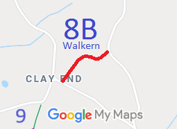
Commences from Clay End Road (public highway) at TL 3053 2509 then runs generally NE for approx. 245m to a junction with the Bassus Green road (public highway) at TL 3072 2523.
Width: Varies between 6m and 28m as shown in the Hertfordshire County Council (Walkern 8b) Modification Order 2023.
Limitations: None
|
Maintainability
This route is maintainable at the public expense because it was a highway before 1835.
|
Location Information
Postcode for SATNAV for anyone inspecting path: SG2 7JD.
|
|