Paths Greenways Bridleways Tracks
 PG: OBJECTS: PROMOTION: Bushey 25 FP and Watford Rural 13 FP (all desired bridleway)
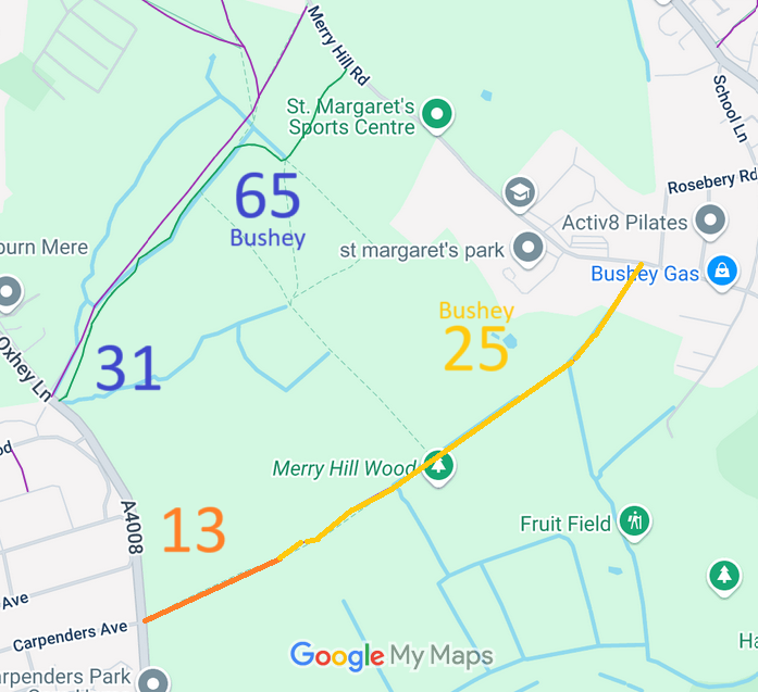
Map showing recorded Bushey and Watford Rural paths
Annotated map reproduced courtesy of Googlemaps.
This route starts from Oxhey Lane (public road) and continues generally north-eastwards to Merry Hill Lane (public road).

We need a volunteer to photograph this route for the Access and Riding Rights of Way Survey. It's easy - just take photographs (safely) when you use the path. Find out more!

PGBT This would be a good route to raise to bridleway status so that it could be used by riders and cyclists as well as walkers. Upgrading Watford Rural 13 and Bushey 25 footpath would allow a different route for riders to Watford Rural 31 and Bushey 65 bridleway, potentially allowing a circular ride in the future. The 2025 planning application proposes to ‘improve’ Watford Rural 13 footpath, and so this may provide an opportunity to achieve an upgrade.

Legal History
25 Jun 25: Planning application 25/1020/OUT to Three Rivers District Council would require Watford Rural 13 FP to be ‘improved’. The proposed route is on wider track that could carry a bridleway easily.
Definitive Statement (4 Dec 2015)
Path: [Watford Rural] 13.  Recorded Status: Footpath.  Definitive Map sheet: 90
Commences at junction with Oxhey Lane N of Carpenders Park Farm and opposite Carpenders Avenue thence NE to parish boundary towards Bushey junction with FP25 Bushey.

Statement could be written much more clearly.

Maintainability
This route is maintainable at the public expense because it was a footpath or bridleway existing before 30 Apr 1959.

© 2025 Patchetts Green Bridleways Trust.

Stats2