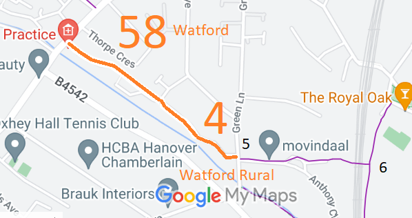
Legal History
20 Jun 1953: Watford Rural 4 was recorded as a footpath on the original definitive map and statement. DM sheet DM3-43 (Herts 44 SW, TQ19SW).
20 Jun 1953: Watford Borough 58 was recorded as a footpath on the original definitive map and statement. DM sheet DM3-43 (Herts 44 NW, TQ19SW).
31 Dec 1977: The route was shown as footpath on the special review draft map and statement. DM sheet SR-90.
29 May 1992: The Borough of Watford (Footpath No. 58) (Eastbury Road to Green Lane) Public Path Diversion Order 1992 (confirmed 16 Sep 1994) diverted Watford Borough 58 FP slightly.
|
|
Definitive Statement (4 Dec 2015)
Path: [Watford Rural] 4. Recorded Status: Footpath.
Definitive Map sheet: 90
Commences at junction with Green Lane opposite Anthony Close at TQ 1135 9438 thence
generally NW following the southern footway of The Oaks, to Parish and Borough of
Watford boundary and its junction with Watford Borough FP58 at TQ 1123 9444.
Width: Minimum 2m.
Path: [Watford Borough] 58. Recorded Status: Footpath.
Definitive Map sheet: 90
Commences from Eastbury Road adjoining No. 95 thence SE at rear of properties to Grid
Ref: TQ1112 9453 extending east for a distance of 17m to a point Grid Ref: TQ1113 9453
thence south east for a distance of 74 metres adjacent to the southwestern boundary of
Meadowbank to TQ1120 9449 thence generally SE along the southern footway of
Meadowbank for approx 60m to its junction with Watford Rural FP4 and the Borough
boundary at TQ 1123 9444.
Width: 2 metres between Grid Ref: TQ1112 9453 and Grid Ref: TQ1119 9448.
Average 1.8m between TQ1120 9449 and TQ 1123 9444.
|
Maintainability
This route is maintainable at the public expense because it was a footpath or bridleway existing before 30 Apr 1959.
|
|