Paths Greenways Bridleways Tracks
 PG: OBJECTS: PROMOTION: Welwyn Ninnings Lane
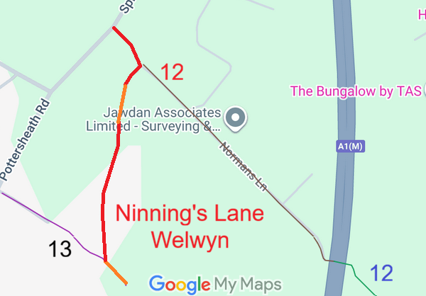
Map showing recorded Hertfordshire paths
Annotated map reproduced courtesy of Googlemaps.
This route starts from Spinney Lane. It passes southeastwards to a junction with Welwyn 12 byway then turns generally southwards to meet Welwyn 13 footpath and continues generally southeastwards to the corner of the wood.

We need a volunteer to photograph this route for the Access and Riding Rights of Way Survey. It's easy - just take photographs (safely) when you use the path. Find out more!

Legal History
1822: Ninning’s Lane was shown on Bryant’s map in the manner of ‘Lanes and Bridleways’.
1837: Ninning’s Lane was shown on the Welwyn tithe map as not subject to an apportionment.
1897: Described as ‘Lane’ in the OS Object Names Book.
1910: Shown as an untaxed white road on the Inland Revenue Valuation Map (Herts 20-15).
2 Feb 1953: The route was not recorded on the original definitive map and statement. DM sheet DM2-7 (Herts 20 SE).
31 Dec 1977: The route was not shown on the special review draft map and statement. DM sheet SR-43 (TL21NW).
2 May 2006: NERC exemption s.67(2)(b) for part of route not on DM but was on LOS. Needs confirmation as shown peculiarly.
10 Jan 2026: The strip of land is unregistered with HM Land Registry. Land on either side (except for two short lengths) is registered.
11 Jan 2026: Application to record route as part BOAT part RB. HCC reference W+H/128.
Application Process
Path Application Certificate Direction Inv Report Order Confirmed
EC1252 11 Jan 26 W+H128 3 Feb 2026        
Definitive Statement (4 Dec 2015)
Path: [Welwyn] TBD.  Recorded Status: Not yet on Definitive Map.  Definitive Map sheet: 43
[This route is not yet recorded on the definitive map and so there is no definitive statement.]
Maintainability
To be determined...

© 2026 Patchetts Green Bridleways Trust. File reference: EC1252. DOBBIN reference: HER-0222. HCC reference: W+H/128.

Stats2