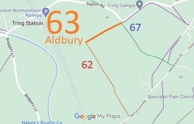
Annotated map reproduced courtesy of Googlemaps.
We need a volunteer to photograph this route for this year's Access and Riding Rights of Way Survey. It's easy - just take photographs (safely) when you use the path. Find out more!
| Paths Greenways Bridleways Tracks | ||
| PG: OBJECTS: PROMOTION: Aldbury 63 | ||
| We're collecting user evidence for the council now: Download user evidence form - Read the Instructions | ||
Annotated map reproduced courtesy of Googlemaps. |
This route starts on Aldbury 62 restricted byway and continues generally northeastwards to join Aldbury 67 bridleway and Station Road (public road).
We need a volunteer to photograph this route for this year's Access and Riding Rights of Way Survey. It's easy - just take photographs (safely) when you use the path. Find out more! |
|||
| If you have ridden the route, please download a user evidence form and then follow the instructions and return the form to us. It only takes a few minutes to fill in (the whole form fits on one side of a piece of A4 paper). If you have any other questions, please email us. | ||||
|
| ||||||||||||||||||||||||||||||
© 2025 Patchetts Green Bridleways Trust.
File reference: EC766.
DOBBIN reference: EC766.
HCC reference: DAC/189.
