Legal History
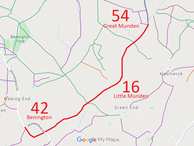
31 Dec 1977: Benington 42, Little Munden 16 and Great Munden 54 were shown as bridleway on the special review draft map and statement. Objections must have been made because the route remained recorded as Road Used as a Public Path (RUPP).
DM sheet SR-31 (TL32SW).
9 Feb 1999: Application to change alignment of Little Munden 16. HCC reference EH/167.
2 May 2006: Restricted Byway rights were confirmed or created on this path by virtue of ss 47 and 48 Countryside and Rights of Way Act 2000.
18 Sep 2009: The Hertfordshire County Council (Little Munden 16 and Benington 42) Modification Order 2009 (confirmed unopposed 29 Jan 2010) varied the alignment and added a width for part of Benington 42 and Little Munden 16 on the definitive map and statement.
27 Nov 2019: The Hertfordshire County Council (Little Munden 7) Modification Order 2019 (confirmed 4 Nov 2021) altered the statement for Little Munden 16 to refer to Little Munden RB7 instead of BW7.
|
|
Definitive Statement (4 Dec 2015)
Path: [Benington] 42. Status: Restricted Byway.
Definitive Map sheet: 31
Commences at junction with county road SW of Cutting Hill thence SE and NE past gravel
pit through wood to TL 3198 2229 then continuing NE for approximately 20 metres to the
parish boundary S of Great Dennis Wood at TL 3199 2230.
Width: Varying width of between 5 and 8 metres from TL 3198 2229 to TL 3199 2230
as shown shaded grey on the plan forming part of the Hertfordshire County
Council (Little Munden 16 and Benington 42) Modification Order 2009
Limitations: None between TL 3198 2229 and TL 3199 2230.
Path: [Little Munden] 16. Status: Restricted Byway.
Definitive Map sheet: 31
Commences from RB 54 (Great Munden) thence generally SW along west bank of the Old
Bourne to a junction with Little Munden RB7 at TL 3218 2253. Continuing generally SW
along both the west bank and the stream bed of the Old Bourne for approx 90m to TL 3212
2247 where both sections re-converge. Continuing SW for approx 210 metres to the parish
boundary N of Comb's Croft at TL 3199 2230.
Width: Varying width of between 8 and 11 metres from TL 3218 2253 to TL 3199 2230
as shown shaded grey on the plan forming part of the Hertfordshire County
Council (Little Munden 16 and Benington 42) Modification Order 2009
Limitations: None between TL 3218 2253 and TL 3199 223
Path: [Great Munden] 54. Status: Restricted Byway.
Definitive Map sheet: 31
Commences from Restricted Byway 16 (Little Munden) thence NE along parish boundary on
W side of The Old Bourne to join county road at junction with FP's 18 and 19.
|
Maintainability
This route is maintainable at the public expense by virtue of s.49(1) Countryside and Rights of Way Act 2000. [RB converted from RUPP]
|
|