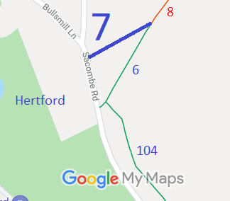
Legal History
2 Feb 1953: Hertford 7 was recorded as a footpath on the original definitive statement. DM sheet DM2-21 (Herts 29 NE).
31 Dec 1977: Hertford 7 was shown as a footpath on the special review draft map and statement. DM sheet SR-59 (TL31SW).
30 Apr 1993: Application to upgrade Hertford 1, 2, 6 and 7 FP and Bengeo Rural 12 and 14 FP to bridleway. HCC reference EH/36/MOD.
5 Apr 2012: The Rickneys Quarry Public Path Creation Agreement 2012 was made by the Hertfordshire County Council and the landowner. This upgraded Hertford 7 FP to BW and made other changes. HCC reference EH/362/CRE.
22 Jun 2012: The Hertfordshire County Council (Hertford 6, 7 & 104 and Bengeo Rural 12) Legal Event Modification Order 2012 recorded this route as a bridleway.
|
Definitive Statement (4 Dec 2015)
Path: [Hertford] 7. Status: Bridleway.
Definitive Map sheet: 45
To Chapmore End. Commences from Sacombe Road at TL 3177 1527 and runs NE for
approx. 125m to join Hertford RB 8 at TL 3188 1534.
Width: 4m
Limitations: None
|