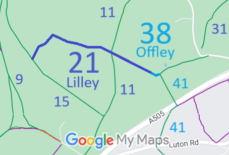
Annotated map reproduced courtesy of Googlemaps.
We need a volunteer to photograph this route for this year's Access and Riding Rights of Way Survey. It's easy - just take photographs (safely) when you use the path. Find out more!
| Paths Greenways Bridleways Tracks | ||
| PG: OBJECTS: PROMOTION: Lilley 21 and Offley 38 | ||
Annotated map reproduced courtesy of Googlemaps. |
This route starts as Offley 38 bridleway from Offley 41 bridleway and continues to the parish boundary. It continues as Lilley 21 bridleway generally northwestwards, across Lilley 11 bridleway before turning southwestwards to end on Lilley 15 bridleway.
We need a volunteer to photograph this route for this year's Access and Riding Rights of Way Survey. It's easy - just take photographs (safely) when you use the path. Find out more! |
| Legal History 1938: The route is shown as Lilley BW 18 and Offley BW 38 on the Hertfordshire County Council ROW survey. Map Hitchin Rural West 7 (Herts 9 NE). 1 Nov 1953: Lilley 21 and Offley 38 were recorded as bridleways on the original definitive map and statement. DM sheet DM4-28 (Herts 11 NE). 31 Dec 1977: Lilley 21 and Offley 38 were shown as bridleways on the special review draft map and statement. DM sheet SR-19 (TL12NW). |
Definitive Statement (4 Dec 2015)
Path: [Lilley] 21. Status: Bridleway. Definitive Map sheet: 19 Commences from BR15 E of Stockinghill Plantation thence NE along W edge of Mazebeard Spring to NW corner of same thence SE across BR11 to join BR38 (Offley) at parish boundary at Honeysuckle Lane. Path: [Offley] 38. Status: Bridleway.
Definitive Map sheet: 19 |
© 2021 Patchetts Green Bridleways Trust.