Paths Greenways Bridleways Tracks
 PG: OBJECTS: PROMOTION: Little Munden 7
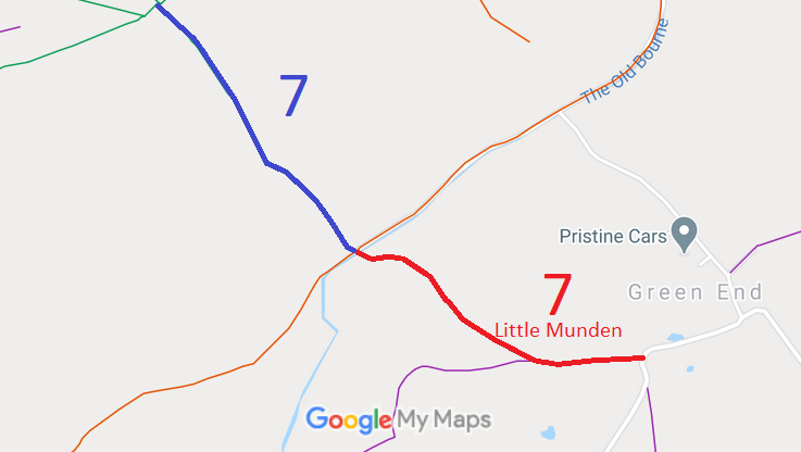
Map showing Little Munden 7
Annotated map reproduced courtesy of Googlemaps.
This track runs generally north-eastwards from Green End Lane (public road) to a junction with Little Munden 16 bridleway and then to a junction with Benington 22, Benington 11 and Benington 26 bridleways at the parish boundary.

We need a volunteer to photograph this route for this year's Access and Riding Rights of Way Survey. It's easy - just take photographs (safely) when you use the path. Find out more!

BHS As part of the British Horse Society's work to record paths before Path Extinguishment Day, it was spotted that the section of Little Munden 7 from Green End Lane to Little Munden 16 restricted byway was actually an old road, so an application was made to record it as a restricted byway. The County Council agreed with the application and an order was made in 2013 and confirmed unopposed in 2021. This is a good example of a ‘perfectly obvious path’ that would be have been extinguished by the Countryside and Rights of Way Act 2000 had an application not been made in time.

Legal History
23 Mar 2013: Application to record part of Little Munden 7 BW as RB. HCC reference EH/413.
27 Nov 2019: The Hertfordshire County Council (Little Munden 7) Modification Order 2019 (confirmed 4 Nov 2021) recorded the part of Little Munden 7 bridleway south of the Old Bourne as a restricted byway on the definitive map and statement.
Application Process
Path Application Certificate Direction Inv Report Order Confirmed
EC715 23 Mar 2013 EH/408 23 Mar 2018 Not requireed 1 Oct 2019 27 Nov 2019 4 Nov 2021
Definitive Statement (26 Nov 2019)
Path: [Little Munden] 7.  Status: Restricted Byway and Bridleway.  Definitive Map sheet: 31
Commences from Green End Lane (public road) at TL 3281 2232 then runs W for approximately 280m to junction with FP 12 at TL 3254 2230. Continues generally NW for approximately 465m following the track between Graves Wood and Banfield Wood to the Old Bourne and a junction with Little Munden RB 16 at TL 3218 2253. Continues as a bridleway NW to parish boundary.
Width: Varies between 4m and 29m as shown excluded from hereditaments on the 1910 Finance Act map and shown in the Hertfordshire County Council (Little Munden 7) Modification Order 2019, between TL 3281 2232 and TL 3218 2253.
Limitations: None between TL 3281 2232 and TL 3218 2253.
Maintainability
This route is maintainable at the public expense because it was a highway before 1835.
This route is maintainable at the public expense because it was a footpath or bridleway existing before 30 Apr 1959.

© 2025 Patchetts Green Bridleways Trust. File reference: EC715.

Stats2