Paths Greenways Bridleways Tracks
 PG: OBJECTS: PROMOTION: St Stephen proposed new routes B004 and B009 (as part of Railfreight changes)  CMP6 
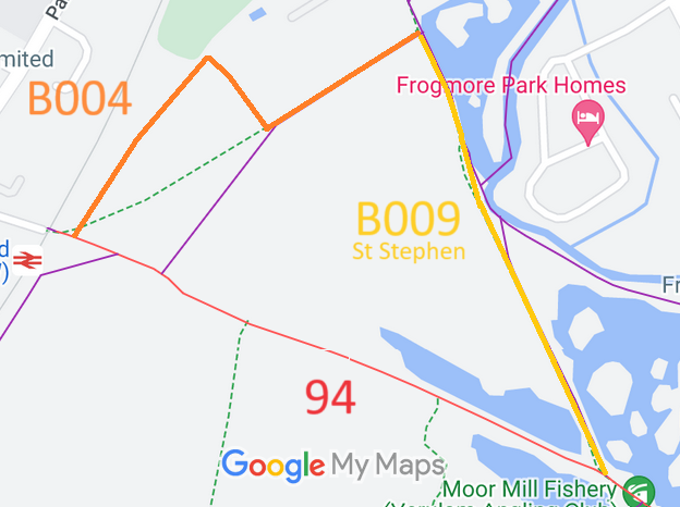
Map showing recorded St Stephen paths
Annotated map reproduced courtesy of Googlemaps.
Proposed route B004 starts from Hyde Lane (St Stephen 94 restricted byway) and continuesgenerally northeastwards (parallel to the disused railway line) then southeastwards and northeastwards around the primary school to meet proposed route B009.

Proposed route B009 starts from proposed route B004 and continues generally southwards to meet Hyde Lane (St Stephen 94 restricted byway).

Recording notes: Part of B004 is currently recorded as St Stephen 33A footpath. Part of B009 is currently recorded as part of St Stephen 87 footpath, and part is recorded as St Stephen 26 footpath.

BHS PGBT We would very much like to include the current footpath (part of St Stephen 87) from the northern end of B009 to Boundary Road (public road), as this would provide an exist for riders wishing to head towards Burydell Lane (St Stephen 85 bridleway) and the proposed new paths accessed from that route.

Legal History
Definitive Statement (4 Dec 2015)
Path: [St Stephen] 33A.  Current Status: Footpath.  Definitive Map sheet: 76
Commences at Hyde Lane thence NE to junction with FP87 (formerly St Albans City FP78) SE of Park Street School.

Path: [St Stephen] 87.  Current Status: Footpath.  Definitive Map sheet: 76
Commences from Park Street Lane hand gate into recreation ground to bridge under disused railway track. Continues S between garden fences, along boundary crosses boundary out of City adjoining loop in River Ver.

Path: [St Stephen] 26.  Current Status: Footpath.  Definitive Map sheet: 76
Commences at junction with Hyde Lane just W of River Ver thence NE to end of Branch Road.

© 2023 Patchetts Green Bridleways Trust. File reference: ED124.

Stats2