The diagram below shows riding routes in Shenley and surrounding areas. In the Parish of Shenley, path numbers are given in blue. The red numbers refer to the key below the map - these are potential changes that could be of benefit to riders. The H25 London Orbital Bridleroute has been shown by purple dots along its route.
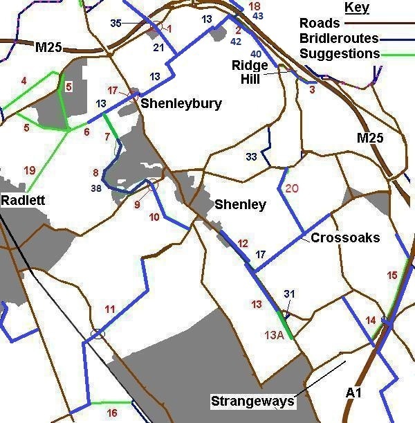
Schedule of Changes
| No. | Description | |
| 1 | Bell Lane Pegasus crossing 20 Oct 05: This crossing had its official opening! It makes a safer crossing for the H25. | |
| 2 | BW link from Shenley 13 to Ridge Hill.
30 Mar 11: The public path creation agreement has come into effect. Part is now brideway 42 Shenley. The definitive map modification order has now recorded the Old St Albans Road as a restricted byway, so we now have a through route. | |
| 3 | Verge improvement. Works took place in Aug/Sep 08 to improve this verge! | |
| 4 | BW link from St Stephen 5 to Harper Lane opposite Hospital site. Oct 06: This path is offered as part of the Radlett Railfreight planning application 28 Jan 10 Part of route 4 is offerered as part of an advertised scheme, now not dependent on the railfreight terminal. :-) | |
| 5 | BW links in Harperbury Hospital as it gets redeveloped. (Only outer routes shown on plan.) | |
| 6 | BW link from Shenley 13 to Harperbury Hospital new paths | |
| 7 | BW link from New Shenley to Shenley 13. 7 Aug 09: This path is now open for use. | |
| 8 | BW link round New Shenley (Porters Park Estate). 7 Aug 09: This path is now open for use. 28 Oct 09: Official opening by the Mayor of Hertsmere, Cllr Rosemary Gilligan. | |
| 9 | Crossing improvement on Radlett Lane | |
| 10 | BW link from Radlett Lane to Woodhall Lane | |
| 11 | BW link from Tykeswater Lane/Theobald Street to Woodhall Lane Jul 05: This is currently being considered by HCC based on evidence of an old route here. | |
| 12 | Verge improvement on London Road to Shenley 17 Mar 10: Route under construction by HCC. Official opening: 26 May 11 | |
| 13 | Verge improvement from Shenley 17 along Silver Hill to the junction of Well End Road and High Canons. Official opening: 26 May 11 | |
| 13A | New bridleway parallel to Well End Road, from opposite Wheatsheaf Farm to the junction of High Canons, Silver Hill and the desired route 13 above. | |
| 14 | Verge improvement from Packhorse Lane to good crossing point for BW bridge | |
| 15 | Verge improvement along A1 from BW bridge to Blanch Lane, or better route inside the hedge. | |
| 16 | BW link from Parkfields riding route to Tykeswater Lane | |
| 17 | Improve crossing at Shenleybury 2014: consultations took place with a view to work happening in 2015. | |
| 18 | Use M25 underbridge and create path to link to Colney Heath Oct 06: This is currently being offered as part of a minerals extraction planning application. 1 Jun 10: HCC statutory consultation on the creation order needed to cross DfT land (M25). 30 Mar 11: The creation agreement has come into effect, but some works are required before the path can be used. This is now Shenley 43 BW and Ridge 40 BW. | |
| 19 | From Margaret Cottages to The Warren, Radlett. Dec 06: This is currently being considered as part of a cycle route plan. Contact the Trust urgently if you would like to use it on horseback! | |
| 20 | From Mimms Lane to Crossoaks Lane. Nov 09: This route will be added by the Hertfordshire County Council (Ridge 37, 39 and Shenley 39) Modification Order 2009 if it is confirmed. |
Bridleroutes on the Definitive Map in Shenley
This is a list of bridleroutes that have already been recorded. There are many that are not on the definitive map but are still legal routes - after all, you wouldn't expect the road outside your house to be recorded! The routes are recorded as bridleways unless otherwise stated.
| No. | Description |
| 13 | From Parish boundary, east to Shenleybury then further east via Salisbury Hall to the B556. (Part H25) |
| 17 | From London Road to Crossoaks Lane |
| 21 | From Shenley 13, northwards to Bell Lane (H25) |
| 31 | From Well End Road to High Canons |
| 33 | Byway From Mimms Lane to Rectory Lane. [Recorded 16 Jul 1998] |
| 35 | From Bell Lane, northwards to bridge over M25 and London Colney 1 at the parish boundary (H25). [Recorded 29 Jan 1992] |
| 38 | From Radlett Lane to Shenley 36 at Porters Park, New Shenley. [Recorded 2 Oct 2009] |
| 40 | From Shenley 13 and Farm Close, round buildings to Shenley 13, Shenleybury. [Recorded 5 Mar 2010] |
| 41 | From Shenley 13 and Farm Close, round buildings to Shenley 13, Shenleybury. [Recorded 5 Mar 2011] |
| 42 | Bridleway from Shenley 13 to Old St Albans Road [Dedicated 10 Feb 2010] |
| 43 | Number reserved for use as part of scheme for link (18) above |