
2009 Retrospective
Shenley 38
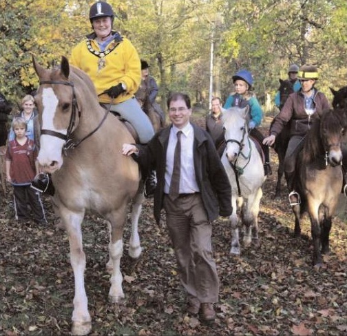 Many years ago, when the plans for the redevelopment of the old Shenley Hospital into housing were first considered by Hertsmere Borough Council (as local planning authority), the master plan for the area showed a proposed bridleway round the western side of the site. Nothing happened for several years, so our Trustees set about influencing applicants for planning permissions to get the route of the bridleway specified.
Progress was slow, and depended on different sections of the land being developed. Several small sections were achived. After these successes, the route was eventually taken on by the Greenways project. Liz Drake of the Borough Council spent a couple of years trying to gain the legal agreements needed to create the path (with our encouragement, of course).
By June 2007, the land owners concerned had agreed to the details of the path. The legal documents to create the bridleway were circulated for signatures and seals. Once all the signatures and seals were in place, some work was needed to remove blockages and ensure access is safe for horses and riders. When all was completed we held official opening (see photograph) on 28 October 2009 by the Mayor of Hertsmere, Her Worship Cllr Rosemary Gilligan.
 The need to record this route was uncovered when the Patchetts Green Riding Club was conducting the survey of routes ridden as part of the British Horse Society's 1991 ARROW survey. It was found to be a popular route from Aldenham towards Blackbird's Lane, as part of a circular route. Accordingly, an application was made (in 1997) to ensure that riders were not prevented from using the route in the future.
Subsequently, with the development of the Wall Hall site for housing, the County Council and the Developer agreed to formalise many of the routes riders had been using, which would also save the wait for the definitive map modification order applications to reach the top of the queue. This route was owned by the developer, Octagon, and has been dedicated for the avoidance of doubt. This was done by means of a public path creation agreement, and so the path is maintainable at the public expense. This route is now recorded as Aldenham 87 bridleway.
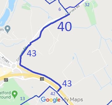 We were really pleased to hear that keeping friendly relationships with local landowners and having a long terms plan for riding routes in the area have combined to help us get a link bridleway. The Tyttenhanger estate will be creating a bridleway to link the Old St Albans Road to Shenley 13, so making a permissive section permanent, and adding a bridleway through an M25 accommodation underbridge and running to Coursers Road where bridleway 6 Ridge starts. This will be a major accomplishment, and we thank the Trustees of the Tyttenhanger Estate, Sam Legerton, the BHS, Hertsmere and County for their respective involvements. As soon as the route is ready to open, we’ll post news on the email newsletter and on our new Twitter account!
 Following complaints from riders that an obstruction was blocking the path, it was found that the route was recorded only as a footpath, despite having been promoted by Stevenage Boorough Council as part of its Horse and Pony Route. One of the British Horse Society's access officers researched the historical evidence and found that the route had been a public road.
An application to show the route on the definitive map as a byway was made in 2006. The County Council's definitive map officers agreed there were historic vehicular rights and made an order to record the route as a restricted byway. The order was subsequently confirmed unopposed and the obstruction was removed.
This is a good example of ‘perfectly obvious paths’ that would be extinguished by the Countryside and Rights of Way Act 2000 had an application not been made and processed in time.
 This route runs from Northaw Road West generally southwestwards to Coopers Lane Road. The northern section was missing from the definitive map so we worked with the British Horse Society to make an application in 2004 for this section based on historical evidence. The rest of the route was recorded as a footpath, and after the North Mymms Riding Club collected evidence of use on horseback, we used that to apply for an upgrade of the footpath.
The County Council agreed with the application and made the order. As there were no objections, the County Council was able to confirm the order itself, and this happened just in time for Christmas, on 23 December 2009.
A special acknowledgement is due to the North Mymms Riding Club for collecting the user evidence which helped have the full route recorded for riders.
 Oakridge Lane, oftern referred to as ‘The River Ride’, runs from Watling Street and the junction with Aldenham 20 restricted byway, to the River Colne, along the river bed, then out, across the private drive and on to the junction with Aldenham 72 bridleway.
This route was identified as in use and not recorded on the definitive map when members of the Patchetts Green Riding Club surveyed the riding routes in the area as part of the British Horse Socety's Access and Riding Rights of Way survey in 1991. As it was legally a road, with numbers 4U23/30 and 4U23/40, it did not need to be recorded on the definitive map. However in 2006, Parliament decided that byways open to all traffic would no longer be able to be recorded from 2026. The Trust and BHS made an application to record the route in 2006.
We were pleased that this year the County Council agreed with our application and has made an order to record the route as Aldenham 83. We now wait to see whether there are any objections.

The Hertfordshire County Council (Northaw 10 and 16) Modification Order 2009, made 4 Sep 2009 and confirmed 23 Dec 2009, added Hook Lane as a byway open to all traffic and upgraded Northaw 10 footpath to bridleway on the definitive map and statement.
The Hertfordshire County Council (Aldenham 84, 85, 86 and 87) Legal Event Modification Order 2009, made 11 Dec 2009, recorded Wall Hall, Aldenham, routes on the definitive map and statement.
The Wall Hall Public Path Creation Agreement 2009, made 9 Oct 2009, created several paths in the vicinity of Wall Hall, near Aldenham village. These were subsequently numbered Aldenham 84 footpath, 85 footpath, 86 footpath and 87 bridleway. Note that Aldenham 84 is the subject of a DMMO appplication to record as bridleway.
The Hertfordshire County Council (Aldenham 82) Modification Order 2008, made 26 Jun 2008, proposes to add Blackbirds Lane to the definitive map and statement as a restricted byway.
The Hertfordshire County Council (Ridge 37, 39 and Shenley 39) Modification Order 2009, made 30 Oct 2009, proposes to add a bridleway to the definitive map and statement.
The Hertfordshire County Council (Aldenham 83) Modification Order 2009, made 9 Oct 2009, proposes to add Oakridge Lane (the River Ride) to the definitive map and statement as part restricted byway, part byway open to all traffic.

© 2025 Patchetts Green Bridleways Trust.
