
2012 Retrospective
Sarratt 79 and Watford 30
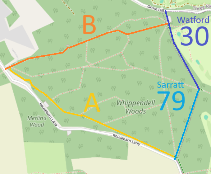 This newly dedicated route is a bridleway linking Grove Mill Lane (public road) to Rousebarn Lane (public road). The bridleway forms part of the Whippendell Woods Circular Ride.
It runs through Whippendell Woods and was created through an initiative by Hertfordshire County Council and Watford Borough Council. There had previously been some equestrian use but this is a permanent right now that the route has been dedicated by Watford Borough Council.
The Trust congratulates all involved.
 As a bonus for our help with path matters on the Woodhall Estate, the section of Shenley 10 from Woodhall Lane to Radlett Lane that falls on estate land has been agreed for upgrade to bridleway.
We need to secure a route through Hertsmere Borough Council’s land off Woodhall Lane to enable us to upgrade the rest of footpath Shenley 10 to bridleway or to put in a different route, before we open the section just upgraded. This is a 2013 project!
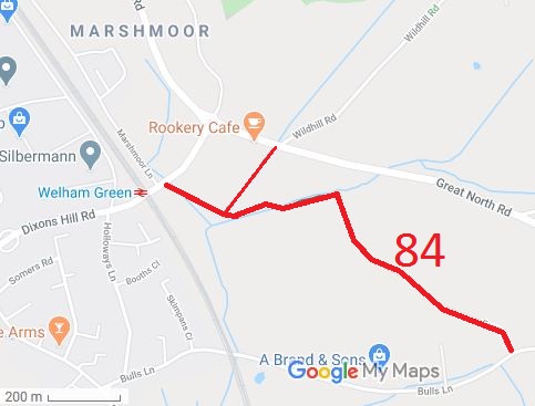 Fox’s Lane runs from Bulls Lane to Dixons Hill Road. The route and the adjoining byway North Mymms 42 are part of the H25 London Orbital Bridleroute.
Our application to record Fox’s Lane was made on 2 April 2002, and resulted in an order for byway status in 2008. There were objections, though, and so an Inspector had to consider these and decide the status of the Lane. In January 2012, we were delighted to hear that he had agreed with our application. The route is now on the definitive map, which provides legal certainty and protection.
It was fantastic to hear in December 2012 that the County Council has scheduled some drainage and surfacing works to make it usable all year round.
This route is covered by a Traffic Regulation Order prohibiting some motor vehicles, unless a permit is obtained from the County Council.
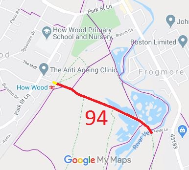 We were pleased when this case made it to the top of the County Council’s priority list and was investigated. The resulting Order to record the route as a restricted byway went through unopposed and the County Council confirmed the order to record St Stephen 94 as a restricted byway in January 2012.
While on its own it is just a cul-de-sac, as the level crossing was closed to horses and vehicles in 1966, it forms part of a longer planned route, with the other landowner unwilling to create a path until this one had been proven. The diagram shows the newly recorded route in red. We aim to form a network of riding routes in this area, working with the British Horse Society, landowners and the local authorities.
 Oakridge Lane was identified as in use and not recorded on the definitive map when members of the Patchetts Green Riding Club surveyed the riding routes in the area as part of the British Horse Socety’s Access and Riding Rights of Way survey in 1991. As it was legally a road with numbers 4U23/30 and 4U23/40, it did not need to be recorded on the definitive map. However in 2006, Parliament decided that byways open to all traffic would no longer be able to be recorded from 2026. The BHS and PGBT made an application to record the route that year.
The County Council decided the route was part byway open to all traffic and part restricted byway on 21 August 2009 and made an order accordingly. Following a round of written representations, an Inspector confirmed the order on 9 Oct 2012.
Post year addendum: Following a High Court challenge on whether the restricted byway part should actually be byway open to all traffic (that is, on the exact meaning of the words in s.67(2)(b) of the Natural Environment and Rural Communities Act 2006), the order’s confirmation was quashed, and needs to be redetermined.
The rights of ridden and driven horses are confirmed as existing, but the processes to enable rights to be added to the definitive map will take a little longer.

The Hertfordshire County Council (St Stephen 94) Modification Order 2011, made 14 Feb 2011 and confirmed 13 Jan 2012, added Hyde Lane to the definitive map as a footpath over the former level crossing, and restricted byway for the rest of its length.
The Hertfordshire County Council (Watford Borough 30 and Sarratt 79) Legal Event Modification Order 2012, made 21 Sep 2012, added the bridleway created by the Whippendell Woods Creation Agreement to the definitive map and statement.
The Hertfordshire County Council (Aldenham 83) Modification Order 2009, made 9 Oct 2009, proposes to add Oakridge Lane (the River Ride) to the definitive map and statement as part restricted byway, part byway open to all traffic.
The Hertfordshire County Council (Ardeley 3, 52 and 53, Great Munden 65, 66 and 67 and Walkern 43) Modification Order 2012, made 20 Jan 2012, proposes to record these several paths as restricted byways.
The Hertfordshire County Council (Hatfield 186 and Sandridge 54) Modification Order 2012, made 16 Nov 2012, will if confirmed, show a route from the road between Fairfold’s Farm and Suttons Farm, to Coopers Green Lane in the Parish of Sandridge, as a restricted byway.

© 2025 Patchetts Green Bridleways Trust.
