
 Sometimes, access work is quick, but more often than not we see results today from initiatives that were started ten or fifteen years ago. At the end of July, we were pleased to hear that work to create a new path in Patchetts Green ten years ago had finally completed.
The path runs from Summerhouse Lane to Pegmire Lane. The owner of Stilegates wanted to divert the footpath that crossed his land, and we provided expert advice to help the movement process run smoothly. Part of the deal was to make sure the diverted footpath was wide enough to take a bridleway later on, although the diversion order itself was just for a footpath. In recognition of the help he had received, the landowner then dedicated bridleway rights between the two roads. This was important at the time: the steep corner part of Pegmire Lane furthest away from Patchetts Green was very slippery, so this would enable a better route to be taken by riders, and the British Horse Society were planning a route from Aldenham village to Pegmire Lane, across to Summerhouse Lane, on to the Electricity substation and hence either Hilfield Lane or Letchmore Heath. If the longer route were completed this would become the route of the H25 London Orbital Bridleroute instead of using Summerhouse Lane and the roads at Roundbush.
While the dedication of this part of the route happened a good few years ago, the route couldn't be recorded until some people had started to use it. (Remember, legal status and whether a bridleway is recorded are two different things.) We collected statements of the early adopters and gave these to the County Council with the signed deed of dedication. We had to do this twice because the Council lost the paperwork the first time! Finally, we have the path fully recorded.
 This route starts on Bury Green Road (Cheshunt 71 bridleway) and heads generally eastwards to a junction with the B198 Lt Ellis Way. The bridleway continues on the eastern side of the B198 as Cheshunt 75 bridleway and heads generally northeastwards to end at the A10. Take great care at the crossing of the B198.
The route was recorded following two applications (from the British Horse Society and from East Herts Footpath Society). The County Council agreed with them and made an order to record the route as a bridleway. The order attracted objections. The East Herts Footpath Society led at the the inquiry and the order was confirmed, linking a whole network of paths in the vicinity.
 We were delighted that the land at Woodcock Hill, off Barnet Lane in Borehamwood was recorded as a Village Green in July.
Village Green status means that local people have a right to use the land for lawful sports and pastimes, which includes riding horses.
In 2007, the Trust contributed towards the funding of a barrister at the Woodcock Hill village green inquiry. With the BHS, in 1996 we had collected evidence of riding on this land off Barnet Lane, and we submitted this to the inquiry. WHOSE (Woodcock Hill Open Space for Ever) led by Cllr Pat Strack collected the other evidence of lawful sports and pastimes on the land, and raised the money for the professional representation needed.
 On 15 Feb 08, a route in Watford Rural parish, running parallel to the railway line, was added
to the definitive map as a Restricted Byway. This means it carries a right of way for walkers, riders, cyclists and horse drawn vehicles. However, narrow link paths mean that it is unlikely that a cart would be able to use it as a through route.
The County Council has made an order to record a route in Watford Rural parish as a restricted byway. Initially the application in 1998 for bridleway by the British Horse Society's access officer for Hertsmere was turned down. On appeal, the Secretary of State directed that an order be made for restricted byway. We now wait to see if there are objections.
There was one representation, which was subsequently withdrawn, and so the order was confirmed as unopposed.
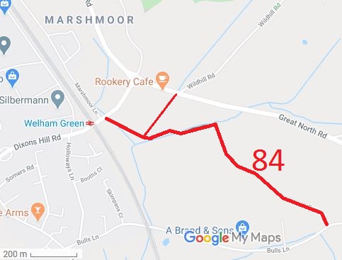 The application to record Fox’s Lane was made on 2 Apr 02, and was another of our applications to be determined in 2008. An order for byway status was made on 28 Feb 08, and there were a couple of objections. As with Blackbirds Lane, Aldenham, the County Council are seeking the withdrawal of the objections in order that they can confirm the order. If any objections remain, it will be sent to the Secretary of State for determination.
 The application to record Blackbirds Lane was made on 3 Jan 06, and we were pleased that the case was determined by the County Council this year: an order to record the route as Aldenham 82 restricted byway was made on 26 Jun 08.
There were a couple of objections, and the County Council are trying to resolve these. If they are not withdrawn, then the order will be sent to the Secretary of State, who will most likely cause a public inquiry to be held.
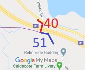 Our application, with the British Horse Society, to record the bridge over the M1 to join Hilfield Lane to Hilfield Lane South as a bridleway was made in 1996, and turned down by the County Council in 2007. The route is currently recorded as a footpath but has mounting blocks at each end, which we think is a clear indication that the route is intended for use by equestrians. Without this route, Bushey 51 bridleway would be a cul-de-sac. An appeal was lodged with the Secretary of State, and we await its determination.
 Back in 2003, there was an official opening of a new bridleway from Arkley Lane to Galley Lane on land owned by the County Council. Although the route has been open since that time, it was only in October 2008 that the legal work to record the path was completed. The Trust believes it is important to follow up on the administrative aspects until they are complete, since otherwise paths believed to exist could turn out not to and then be withdrawn. The path is bridleway number 80 in Potters Bar parish.
Photo: The official opening of the bridleway on 23 Sep 2003.
 We were pleased to see the results of the verge improvements just south of Ridge Hill, organised by Dawn Grocock of the County Council.
This improvement was one of those asked for by the Trust following the consultations for the Shenley Parish Travel Plan, so we’re pleased to have achieved some results from those meetings. The works should result in a verge path that is usable all year round. This verge forms part of the H25 London Orbital Bridleroute.

The Hertfordshire County Council (Watford Rural 17) Legal Event Modification Order 2008, made 28 Feb 2008, recorded the part of Watford Rural 17 from Watford Rural 32 to Delta Gain as a bridleway on the definitive map and statement.
The Hertfordshire County Council (Bushey 69) Legal Event Modification Order 2008, made 26 Jun 2008, added the bridleway from Summerhouse Lane to Pegmire Lane that was dedicated in 2001.
The Hertfordshire County Council (Cheshunt 17, 70, 73, 74, 75 and Enfield 002) Modification Order 2005, made 22 Dec 2005 and confirmed 26 Aug 2008, added or upgraded various paths on the definitive map and statement.
The Hertfordshire County Council (Potters Bar 80) Legal Event Modification Order 2008, made 3 Oct 2008, added this bridleway to the definitive map and statement.
The Hertfordshire County Council (Aldenham 82) Modification Order 2008, made 26 Jun 2008, proposes to add Blackbirds Lane to the definitive map and statement as a restricted byway.
The Hertfordshire County Council (Stevenage 57) Modification Order 2008, made 3 Oct 2008, proposes to record this route as a restricted byway on the definitive map and statement.

© 2025 Patchetts Green Bridleways Trust.
