
 8 May 2013: The Shenley 10 Creation Agreement 2013 between Mr Cohen (landowner) and the Hertfordshire County Council upgraded the length of the Shenley 10 footpath in Mr Cohen's ownership to bridleway.
 Bridleway St Stephen 3 is an interesting ancient path. It was set out with a width of 6ft in ancient documents and made it to the modern day as a narrow path on which it was hard to pass anyone let alone anyone else on a horse. We were very pleased this year to see the narrowest part of the path legally widened by the County Council with the consent of the landowners to between 4.4 and 8 metres. We are grateful to the County Council and the landowners for this action.
 The third inquiry into this route was held in January 2016, and we were delighted that the decision letter agreed entirely with our submissions and the user evidence that had been submitted. Our chairman and secretary each gave evidence at the inquiry.
The decision had to be re-advertised, and the Inspector confirmed her decision on papers. The order recording Oakridge Lane as Aldenham 83 byway was confirmed on 6 December 2016.
This may not be the end of the matter though: there is a short period after the County Council publish a notice of the order’s confirmation in which anyone could challenge in the High Court on a point of law. This is what happened after the first inquiry, so we’ll not quite count our chickens yet.
Post-report note: Part of the Order was quashed by the High Court and had to be redetermined.
 We applied to record this route in 1996. Despite achieving a relatively high score in the County Council's prioritisation scheme (23 points) it only started to be investigated in January 2014. An order to record the route as a bridleway was made in December 2015 and advertised in January 2016. On 4 March 2016, the Hertfordshire County Council confirmed it as an unopposed order.
 text
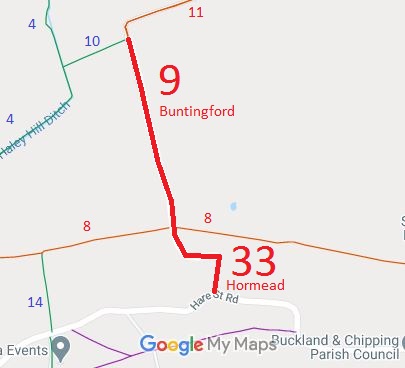 As part of the British Horse Society’s work to record paths before Path Extinguishment Day, our Secretary spotted that Buntingford 9 did not reach the road. The last 102m fell in Hormead parish and had not been recorded. The historical evidence showed a continuous route, so an application was made in 2013 to record the gap. The County Council agreed with the application and an order was made in 2016 and confirmed unopposed. This is a good example of ‘perfectly obvious paths’ that would be extinguished by the Countryside and Rights of Way Act 2000 had an application not been made in time.
 Anstey 9 bridleway was spotted as starting on a public road and stopping a field edge. Investigation showed that it connected to the metalled public road to the south via a green lane, Coltsfoot Lane, which was unrecorded. The evidence suggested that it had been acknowledged as a public road in the 1950s, but had vanished from the official records in the intervening years. The historical evidence looked good, so an application was made in 2013 to record the old road. The County Council agreed with the application and an order was made in 2015 to record Coltsfoot Lane as a restricted byway. It was confirmed by the County Council as an unopposed order.
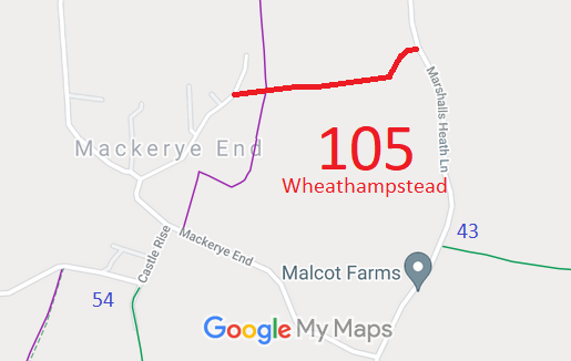 This route starts from Mackerye End (public road) and continues generally eastwards to Marshalls Heath Lane (public road).

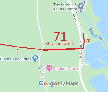
The Hertfordshire County Council (Rickmansworth 2, 70 and 71) Modification Order 2016, made 4 Jul 2016 and confirmed 21 Oct 2016, split the original Rickmansworth 2 BW (Shire Lane) into sections, removed those that had been found to be in Buckinghamshire, and renumbered and upgraded the remaining section as Rickmansworth 71 RB; and added the Old Uxbridge Road to the definitive map and statement as Rickmansworth 70 BOAT.
The Hertfordshire County Council (Hormead 33) Modification Order 2016, made 24 Mar 2016 and confirmed 3 Jun 2016, added Hormead 33 RB to the definitive map and statement and updated the statement for Buntingford 9 RB.
The Hertfordshire County Council (Anstey 20) Modification Order 2015, made 10 Sep 2015 and confirmed 8 Jan 2016, added Coltsfoot Lane as Anstey 20 RB to the definitive map and statement.
The Hertfordshire County Council (Wheathampstead 29 and 105) Modification Order 2016, made 22 Apr 2016 and confirmed 16 Sep 2016, added this route to the definitive map and statement as a restricted byway.
The Hertfordshire County Council (Bushey 73 and 74) Modification Order 2016, made 7 Oct 2016 and confirmed 9 Dec 2016, added two routes to the definitive map and statement as footpaths. The applications to record these routes had been made by the Bushey and District Footpaths Association on 7 May 2002.
The Hertfordshire Council Council (St Stephen 3) Creation Order 2016, made 15 Jul 2016 and confirmed 9 Sep 2016, widened parts of St Stephen 3 bridleway.
The Hertfordshire County Council (Sandridge 1) Modification Order 2016, made 30 Sep 2016, proposes to upgrade the bridleway section of Sandridge 1 to restricted byway on the definitive map and statement, consistent with the rest of the route.
The Hertfordshire County Council (Ardeley 3, 52 and 53, Great Munden 65, 66 and 67 and Walkern 43) Modification Order 2012, made 20 Jan 2012, proposes to record these several paths as restricted byways. Planning Inspectorate reference FPS/M1900/7/81.

© 2025 Patchetts Green Bridleways Trust.
