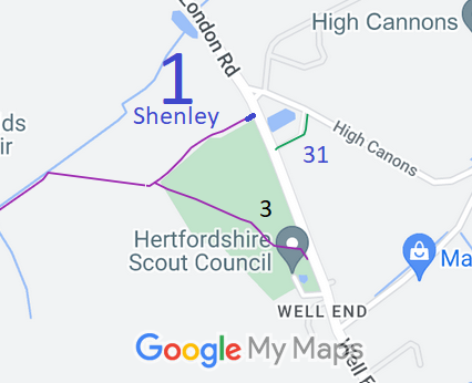
 As part of the Shenley 3 divert and upgrade scheme, the Patchetts Green Bridleways Trust approached the landowner for a dedication of the short section from the proposed new Shenley 3 junction back to the road. The Trust paid the landowner’s agent’s fees for checking the deed of dedication, and the route became a public bridleway on 29 June 2019.
The background to this path being created as a bridleway is that we were very disappointed at the delays caused by Hertsmere Borough Council and Hertfordshire County Council in making the orders to divert and upgrade Shenley 3 FP.
The formal consultation for the scheme to divert footpath Shenley 3 and upgrade it to bridleway was successfully concluded in 2016, and normally orders would follow straight afterwards. There was broad community support for the plan, which would leave riders with an extension to the route along Silver Hill and London Road into Well End.
While waiting for the Councils to do their work, we arranged for part of Shenley 1 FP to be upgraded to BW, so removing the only unaddressed concern that had been raised in consultation about the bridleway status: namely, that it would join on to a public footpath. The Trust paid for the legal work involved by the owners.
We are now waiting for the orders to be made by Hertsmere Borough Council to give effect to the Shenley 3 diversion and upgrade.
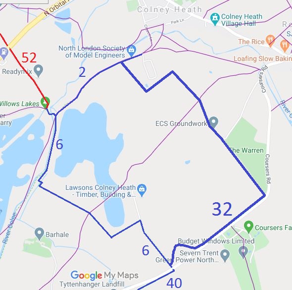 Following much behind the scenes work led by the Ramblers but with PGBT and BHS input for the bridleway aspects, a set of proposals for path changes was agreed by the
Tyttenhanger Estate, its tenants and the user groups. As part of the deal, a bridleway from bridleway Ridge 6 to Colney Heath is diverted to less founderous land, and over a mile of brand new bridleway is created from this path, along the Ridge and Colney Heath parish boundary (approximately) then west to join the northern end of Ridge 6.
The orders and agreements have now been confirmed, but they will not come into effect until some works have taken place on the ground. In the figure the red routes are new or moved bridleways, and the blue lines are existing equestrian routes.
The orders came into effect and the paths were opened for use in 2018.
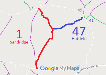 As part of the Patchetts Green Bridleways Trust’s and the British Horse Society’s work to record paths before
Path Extinguishment Day,
it was spotted that a short section (220m) of Sandridge 1 was shown as bridleway on the definitive map, while the rest of the route was shown as a restricted byway. The historical evidence showed a continuous route as an old road, so an application was made in 2015 to record the gap as a restricted byway.
The County Council agreed with the application and an order to change the BW section to RB was made in 2016 and confirmed on 13 Jan 2017 as an unopposed order.
This is a good example of ‘perfectly obvious paths’ that would have been extinguished by the Countryside and Rights of Way Act 2000 had an application not been made in time.
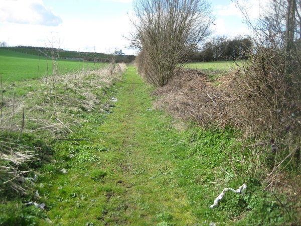 This route was identified as not recorded on the definitive map when members of the Patchetts Green Riding Club surveyed the riding routes in the area as part of the British Horse Socety’s Access and Riding Rights of Way survey in 1991. An application was made in 1997 to record the route and an order to record it was made on 29 Sep 2017.
Post-2017 note: The order was confirmed on 7 Feb 2018.
 This is the route from Aldenham 20 restricted byway to Aldenham 23/St Stephen 10 bridleway (two river’s crossing). The need to record this ridden route was identified as part of the Patchetts Green Riding Club’s surveys for the British Horse Society Year of Access and Riding Rights of Way.
We were delighted at the response from supporters and people they knew after we asked for extra evidence of use of the path by the two river’s crossing (see Annual Report 2016).
We made the application on 1 May 1995, but the County Council only started to process it in 2015. As a result we needed more up to date user statements. The Council made an order to record the path in May, and it was confirmed on 28 July. This route is now protected for use by walkers and riders. Thanks go to those who collected the user evidence to enable this to happen.
 We made an application to record the old Woodrake Lane, linking to the A414 verge opposite
Colney Heath 52 byway, in 2010. We were pleased when it was processed by the County Council. It decided that part of the route had been stopped up reserving footpath rights, so we had to collect statements from riders quickly. Luckily the then BHS county chairman lived nearby and helped out really well. As a result the order was made to record part byway part bridleway.
The order was published in June, and it was confirmed by th eCounty Council as there were no objections, on 11 August. This route is now protected for use by walkers and riders. Thanks go once again to those who collected the user evidence to enable this to happen.
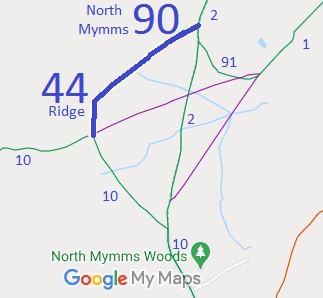 Back in 1991, members of the Patchetts Green Riding Club surveyed their riding routes as part of the British Horse Society’s Year of the ARROW (Access and Riding Rights of Way). After the report was compiled, we checked which paths were not recorded on the definitive map of rights of way held by the County Council, and made applications (1994) for the missing ones to be recognised.
The County Council made an order recording these routes as bridleways on 30 June 2017, and this was confirmed 1 September 2017.
We were grateful to a former Chairman of BHS Hertfordshire for unearthing correspondence that showed the Estate across whose land the paths run believed the route to be bridleways in the 1970s.

The Hertfordshire County Council (Shenley 10) Legal Event Modification Order 2017 was made and came into effect on 31 Mar 17 to record the effect of the 2016 creation order and 2013 creation agreement, namely by upgrading Shenley 10 footpath to bridleway on the definitive map and statement.
The Hertfordshire County Council (Ardeley 3, 52 and 53, Great Munden 65, 66 and 67 and Walkern 43) Modification Order 2012, made 20 Jan 2012 and confirmed (modified) 21 Feb 2017, recorded these several paths as bridleways. Planning Inspectorate reference FPS/M1900/7/81.
The Hertfordshire County Council (Colney Heath 60) Modification Order 2017, made 19 May 2017 and confirmed 11 Aug 2017, added Woodrake Lane to the definitive map and statement as part byway and part bridleway.
The Hertfordshire County Council (North Mymms 90, 91 and Ridge 44) Modification Order 2017, made 30 Jun 2017 and confirmed 1 Sep 2017, added these paths to the definitive map and statement as bridleways.
Changes to paths were made by the Hertfordshire County Council (A120 (Little Hadham) Bypass Classified Road) (Side Roads) Order 2017. This affected paths Bishop's Stortford 9 BW, Bishop's Stortford 10 BW, Little Hadham 35 BW, Little Hadham 36 BW, and various footpaths.
The Hertfordshire County Council (St Stephen 96) Modification Order 2017, made 29 Sep 2017, proposes to add Featherbed Lane (East of the M1) to the definitive map and statement as a byway for open to all traffic.
The Hertfordshire County Council (Chorleywood 25, Rickmansworth 18 and 19) Modification Order 2017, made 29 Sep 2017, proposes to upgrade these footpaths to bridleway on the definitive map and statement.

© 2025 Patchetts Green Bridleways Trust.
