
2011 Retrospective
Shenley London Road Verge
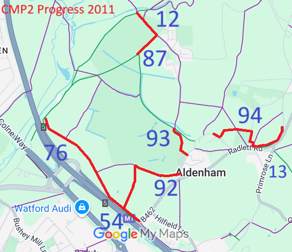 By far the most exciting development in Aldenham this year was the construction and physical opening of various new routes on County Council owned land in Aldenham village itself. At the time of surveying, the exact line of Aldenham 94 bridleway is still being determined. Legal work has been completed for Aldenham 87 bridleway. That for the Berrygrove Woods path (Aldenham 76), the line to Aldenham village (Aldenham 92), The Crescent (Aldenham 93) and the path by the side of the golf course (Aldenham 12) is now merely awaiting formalities to be completed.
The Trust thanks the County Council Rural Estates team for agreeing to the paths on their land, the tenant farmers who agreed to them, and the Rights of Way Service for processing the legal aspects and signing the routes.
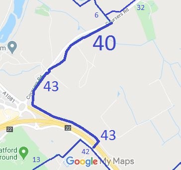 This route starts opposite Ridge 6 bridleway on Coursers Road. It then runs roughly parallel to the road, turns to follow the side of the M25 motorway, and uses an underbridge to come out onto the B556 opposite bridleway Shenley 42 bridleway.
The route was created by a public path creation agreement in conjunction with the minerals extraction nearby. It forms part of a ride from Shenley to Colney Heath. We thank the Hertsmere Borough Council Greenways project, the Hertfordshire County Council, and the Trustees of the Tyttenhanger Estate for making this route a reality.
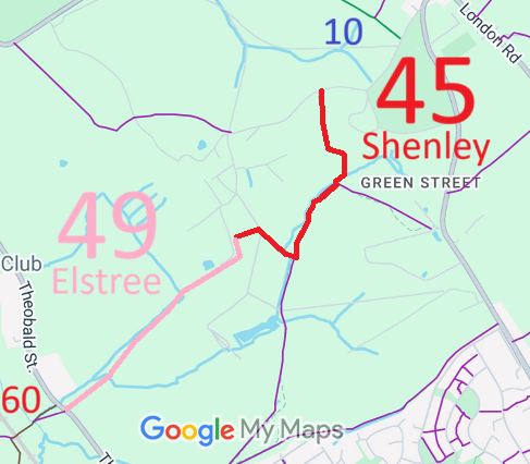 The September 1994 application to record Woodhall Lane, which joins Theobald Street and Tykeswater Lane to Shenley, resulted in an order being made in July 2005. There were objections, but a diversion package was agreed in principle with the landowners which results in overall gains for riders. After two rounds of public consultation, further orders were then made, and on 21 October 2011 they were finally confirmed as Elstree 49 and Shenley 45 restricted byways. This has been a real marathon! The resulting restricted byway is illustrated.
This route now forms part of the Aldenham Parish Ride, and the Greenway from Oxhey to Shenley.
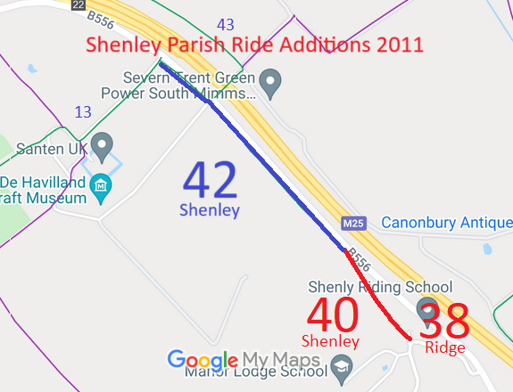 The second major achievement for Shenley (and in part, Ridge) was the recording of the Old St Albans Road and legal creation of the rest of the route needed so that riders can get from Shenley 13 bridleway to Ridge Hill without going onto the B556.
The trust is grateful to Mr Legerton and Lafarge Aggregates for agreeing to the route creation, and to the County Council’s rights of way team for processing both sets of orders.
This route forms part of the H25 London Orbital Bridleroute and the north-western part of the Shenley Community Circuit, both part of the Ride-UK National Bridleroute Network.
In addition to the creation of legal rights of passage, the entire route has been made into what we hope will function as an all year surface.
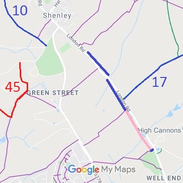 The third exciting event in Shenley was the opening of the route alongside London Road. This had been constructed in the very overgrown verge. Dawn Grocock at the County Council used some of the rights of way budget to do this. The works involved clearing some parts, putting down a firmer (but natural looking) surface, and culverting a ditch in a few places.
This was one of the improvements for riders and others identified as part of the work on the Shenley Local Transport Plan. It gets horses off London Road and links to a permissive path (shown in pink) negotated by Dawn with Wrotham Park.
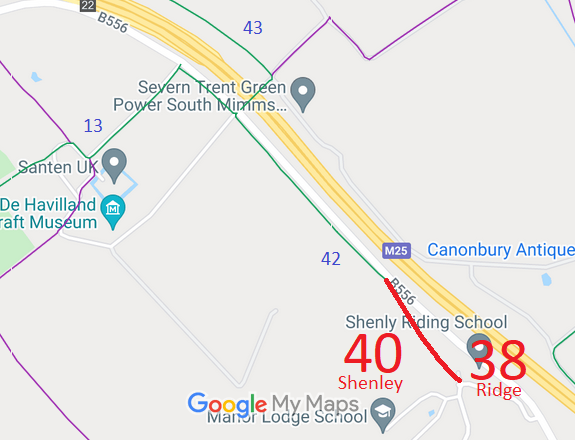 The route forms part of the historic St Albans Road which became the A6. As the A6 became busier, a new A6 route was constructed to the east, and this route became a side road. In 1965, the A6 was made a clearway by the Minister of Transport, and it was decided that motor vehicles should not use the old route to join the A6 trunk road. As the road fell into disuse by motor vehicles, its surface started to be covered by leaves and mud so that to a casual observer it was impossible to tell the difference between the roadway and the land either side. When the M25 was constructed, the builders forgot to leave an access for the non-motorised users to join the B556 (old A6).
The route was reopened by the Highways Partnership (Hertsmere Borough Council and Hertfordshire County Council) on 14 Jun 1997 after pressure from the BHS and PGRC local access officer, as it was needed for the H25 London Orbital Bridleroute. The reopening meant that half the length of the B556 could be removed from the H25, so improving safety and enjoyment of the H25 route.
In parallel, an application was made to record the route on the definitive map. The County Council agreed with the application and an order was made in 2016 and confirmed unopposed.
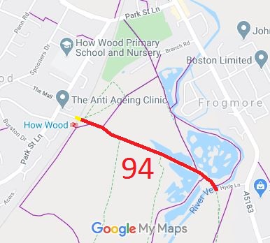 We were pleased when this case made it to the top of the County Council’s priority list and was investigated. The resulting Order to record the route as a restricted byway went through unopposed and the County Council advised in December that the route would be confirmed as St Stephen 94 restricted byway.
While on its own it is just a cul-de-sac, as the level crossing was closed to horses and vehicles in 1966, it forms part of a longer planned route, with the other landowner unwilling to create a path until this one had been proven. The diagram shows the newly recorded route in red. We aim to form a network of riding routes in this area, working with the British Horse Society, landowners and the local authorities.

The Hertfordshire County Council (Ridge 40, 42 and Shenley 42, 43, 44) Legal Event Modification Order 2011, made 14 Oct 2011, recorded the effect of the Tyttenhanger Phase 4 changes on the definitive map and statement.
The Hertfordshire County Council (Shenley 40 and Ridge 38) Modification Order 2011, made 10 Jun 2011 and confirmed 18 Nov 2011, added the Old St Albans Road as a restricted byway to the definitive map and statement.
The Hertfordshire County Council (Ridge 37, 39 and Shenley 39) Modification Order 2009, made 30 Oct 2009, proposes to add a bridleway to the definitive map and statement.
The Hertfordshire County Council (Aldenham 83) Modification Order 2009, made 9 Oct 2009, proposes to add Oakridge Lane (the River Ride) to the definitive map and statement as part restricted byway, part byway open to all traffic.

© 2025 Patchetts Green Bridleways Trust.
